


BCREPC SitRep #001 | Major Winter Storm Expected Sunday–Monday | February 21, 2026 | 11:00 AM
Situational Report #001
Date of Release: February 21, 2026
Time of Release: 11:00 AM
Incident or Event Overview
Situation
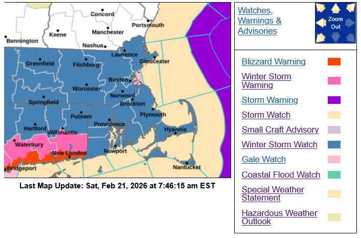
- Winter Storm Watch in effect for Cape Cod and the Islands; expected to transition to a Winter Storm Warning later today as confidence increases.
- Coastal Flood Watch in effect for east-facing coastal areas, including portions of Cape Cod and Nantucket, for potential minor to moderate flooding during Monday tide cycles.
The Barnstable County Regional Emergency Planning Committee (BCREPC) convened a regional coordination call this morning with approximately 200 participants representing local, county, state, nonprofit, and utility partners to prepare for a significant winter storm expected to impact Cape Cod and the Islands beginning Sunday evening through Monday.
Current National Weather Service guidance indicates a high-impact winter storm with heavy snowfall, damaging winds, coastal flooding potential, and the possibility of scattered to widespread power outages. Winter Storm Watches are expected to transition to Warnings later today as forecast confidence increases.
Regional partners report readiness actions underway across all major lifelines, including utilities, healthcare, sheltering, transportation, and public safety. This report provides situational awareness based on the latest meteorological briefing and partner updates.
Impacts / Potential Impacts
Snowfall
Forecast guidance indicates widespread significant snowfall across Cape Cod and the Islands. Current projections include:
- Cape Cod and Islands: generally 12–18 inches possible
- Locally higher totals (near 18 inches) cannot be ruled out
- Lower totals possible on Nantucket and portions of the Outer Cape if brief mixing occurs
Snowfall may be wetter and heavier than recent events, particularly during the peak of the storm, which may increase impacts to trees and power lines. Snowfall rates of 2–3 inches per hour are possible during peak intensity Monday.
Timing and Travel Impacts
- Snow expected to begin Sunday evening (around 7:00 PM).
- Peak impacts anticipated Monday late morning through mid-afternoon (approximately 11:00 AM – 4:00 PM).
- Storm conditions expected to improve Monday evening as the system moves offshore.
- Dangerous travel conditions likely during periods of heavy snow and strong winds Monday.
- Visibility may be significantly reduced at times due to heavy snowfall and blowing snow.
Wind and Power Impacts
- Frequent wind gusts of 60–65 mph are possible.
- Peak gusts up to 70 mph possible, especially across southeastern Massachusetts, the Lower and Outer Cape, and Nantucket.
- The combination of heavy wet snow and strong winds may result in downed trees and power lines.
- Utilities anticipate scattered to potentially widespread outages and a multi-day restoration in some areas.
Coastal Impacts
- Coastal flooding is possible, particularly during Monday tide cycles.
- Inundation of up to approximately 3 feet is possible in vulnerable coastal areas.
- Greatest risk is expected along north- and east-facing shorelines, including Nantucket and exposed coastal communities.
- Timing of peak winds and high tides is still being refined.
Cold Temperatures
- Colder air will follow the storm, with temperatures potentially dropping into the lower teens Tuesday night.
- Temperatures are expected to moderate by midweek, reducing the risk of prolonged extreme cold.
Utilities, Health, and Transportation Readiness (Cape Cod & Islands)
Utility providers report extensive preparations underway:
- Eversource will implement a Level 4 Emergency Response Plan beginning Sunday evening, with regional emergency operations centers activating and additional crews and resources staged across southeastern Massachusetts.
- National Grid is staging line and tree crews in the region, including pre-positioning resources for island communities.
- Utilities are preparing for the possibility of multi-day restoration due to heavy snow and strong winds.
Cape Cod Healthcare and regional healthcare partners report storm preparations underway, including staffing readiness, emergency power verification, and coordination with public safety agencies.
Transportation partners report readiness actions:
- The Cape Cod Regional Transit Authority (CCRTA) is prepared to support transportation to shelters and warming centers once travel conditions are safe.
- Ferry and maritime partners will coordinate service adjustments and resource transport as needed.
- Local Departments of Public Works and public safety agencies report full operational readiness for snow and roadway response.
Residents are reminded to report power outages directly to their utility provider.
Regional Shelter Update & Sheltering and Vulnerable Populations
Emergency shelter partners, including the American Red Cross and regional agencies, are on standby for potential activation if needed following storm impacts.
AmeriCorps Cape Cod teams are prepared to support shelter operations and the Multi-Agency Coordination Center if activated.
Community organizations, including the Family Table Collaborative and other volunteer partners, are prepared to support feeding and shelter operations if activated.
Regional emergency management officials are coordinating with local Emergency Management Directors to assess potential sheltering needs and will provide updates as conditions evolve.
MEMA Operations
The Massachusetts Emergency Management Agency (MEMA) is actively monitoring the storm and coordinating with regional and local partners.
State and regional emergency operations centers are preparing for potential activation beginning Sunday night into Monday to support response and resource coordination.
Barnstable County’s Multi-Agency Coordination Center is currently in the planning phase, with activation timing to be determined based on forecast updates and operational needs.
Preparedness and Safety Information
Residents are encouraged to:
- Avoid unnecessary travel during peak storm conditions.
- Prepare for potential power outages lasting multiple days.
- Charge essential devices and ensure adequate supplies of food, water, and medications.
- Secure outdoor items and check emergency kits.
- Check on neighbors, older adults, and vulnerable individuals.
- Monitor official forecasts and local emergency information.
Community Information and Updates
Shelter openings, warming centers, and local emergency information will be shared through municipal channels and regional partners as needed.
Transportation service changes will be communicated directly by CCRTA, ferry operators, and other service providers.
Utility providers will issue outage and restoration updates through their official channels.
Regional updates will continue to be shared through Barnstable County and BCREPC communication platforms.
Stay Informed
For additional information and updated forecasts, see www.weather.gov/boston (National Weather Service Norton) and www.weather.gov/albany (National Weather Service Albany).
Utilize MEMA’s real-time power outage viewer to stay informed about current power outages in your community and region, and across the state, including information from utility companies about restoration times: http://mema.mapsonline.net/public.html
Online Resources/Links
- Barnstable County Regional Emergency Planning Facebook page: Barnstable County Regional Emergency Planning Committee | Facebook
- Barnstable County Regional Emergency Planning Twitter: Barnstable County REPC (@bcrepc) / Twitter
- Massachusetts Emergency Management Agency: www.mass.gov/mema
- MEMA Facebook page: http://www.facebook.com/MassachusettsEMA
- MEMA Twitter: @MassEMA
- Mass211: www.mass211.org
- Federal Emergency Management Agency: www.fema.gov
- National Weather Service Boston/Norton, MA: www.weather.gov/boston