


Potential Coastal Storm to Impact Cape Cod Sunday Night into Monday
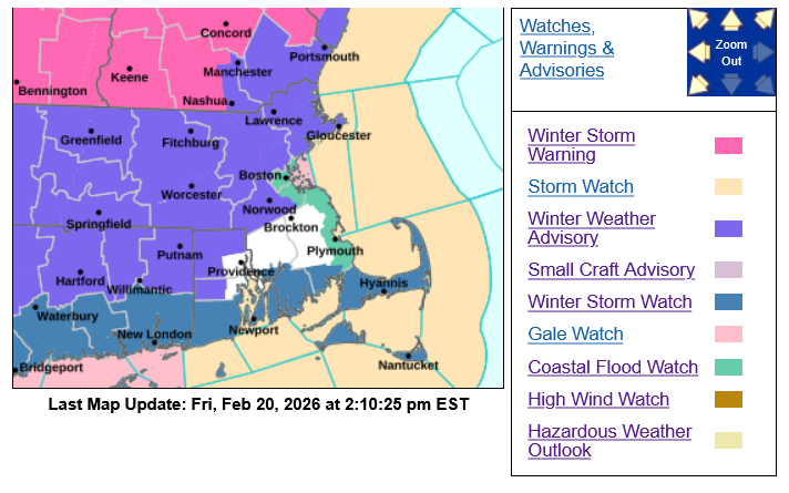
BCREPC Weather Update – February 20, 2026 | 3:30 PM
Barnstable County regional emergency officials are monitoring a coastal storm that may significantly impact Cape Cod and the Islands beginning Sunday night through Monday evening.
Confidence is increasing in a higher-impact scenario that could bring heavy wet snow, strong northeast winds, coastal flooding, and scattered power outages across the region.
Barnstable County and regional emergency planning partners have begun preparatory coordination and will continue monitoring forecast updates closely.

What to Expect on Cape Cod
Timing
Snow is expected to begin late Sunday night. The heaviest snowfall is likely Monday morning through mid-afternoon, with snow and wind impacts continuing into late Monday evening. Travel conditions may deteriorate rapidly Monday morning, with difficult travel possible across the Cape.
Snow
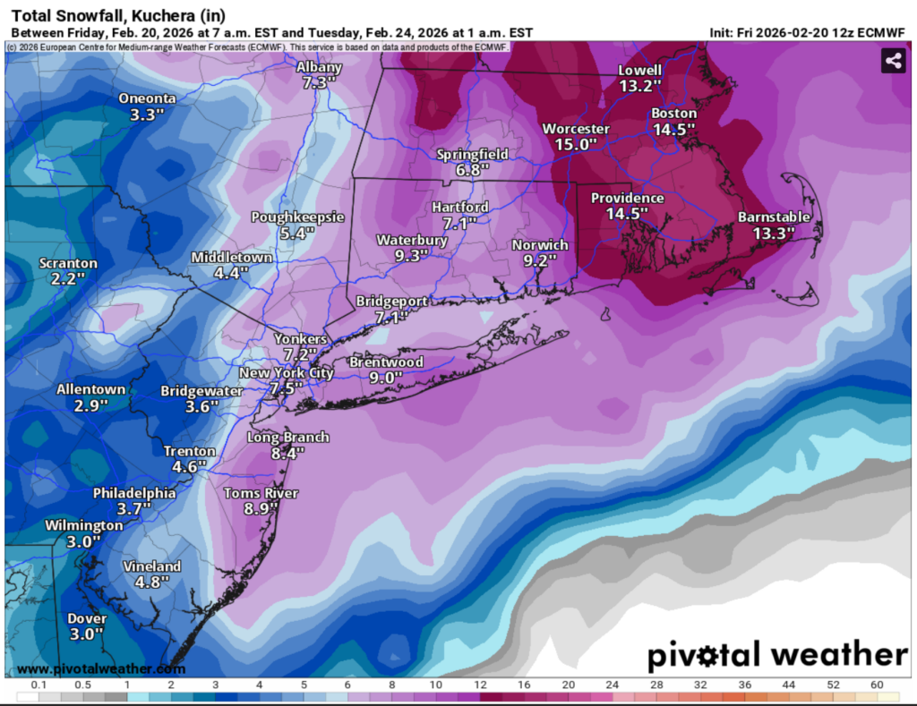
Heavy, wet snow is possible across Cape Cod and the Islands. Exact snowfall amounts remain uncertain and will depend on the storm’s track. Significant accumulation is possible, with more precise totals expected as forecast confidence increases Saturday. Wet, dense snow may make shoveling difficult and contribute to hazardous travel conditions.
Wind
Northeast winds will increase Monday, with sustained winds of 25–35 mph and potential gusts up to 50–55 mph across Cape Cod and the Islands. A High Wind Watch is in effect Monday morning through midnight Tuesday. Strong winds may make travel difficult, especially for high-profile vehicles.
Power Outages and Tree Damage
The combination of heavy, wet snow and strong winds may weigh down tree limbs and power lines, increasing the potential for scattered power outages across the Cape and Islands. Residents are encouraged to charge devices and prepare for possible isolated outages.
Coastal Flooding
Minor to moderate coastal flooding is possible along vulnerable shoreline areas during Monday and Tuesday high tide cycles. Impacts may include splashover or flooding of vulnerable coastal roads, minor inundation of low-lying properties, and beach erosion or shoreline impacts. A storm surge of 2–3 feet and large offshore waves may contribute to these conditions.
Marine Conditions
Hazardous marine conditions are expected, with seas building to 15–20 feet and sustained winds 40–50 knots with gusts up to 55 knots over coastal waters. Reduced visibility and dangerous boating conditions are likely. Mariners should consider altering plans and securing vessels ahead of the storm.
Watches in Effect
(Per NWS Boston/Norton briefing – Feb. 20, 2026 | 2:00 PM)
Winter Storm Watch — South Coast, Cape Cod, and the Islands
High Wind Watch — Cape Cod and the Islands
Coastal Flood Watch — Eastern Massachusetts coastline and the Islands
Storm Watch — Coastal waters (Gale Watch for Boston Harbor)
Forecast confidence and exact impacts remain sensitive to the storm’s track. Even small shifts could increase or decrease snowfall, wind, and coastal flooding impacts across Cape Cod.
Preparedness Reminders
Residents and businesses are encouraged to monitor official weather updates, secure outdoor furniture and loose items, prepare for possible power outages, use caution when traveling Monday, and check on vulnerable neighbors and family members.
Additional updates will be shared as forecast details become clearer and coordination continues across Barnstable County and regional partners.