

BCREPC Situational Report #003 – Winter Storm Update| February 22, 2026 | 5:30 PM
Incident or Event Overview
Situation
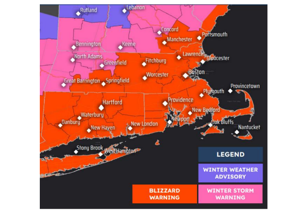
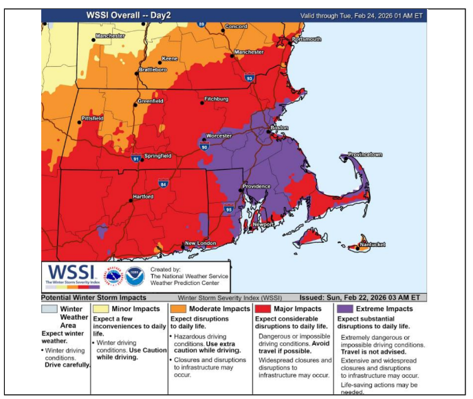
Since the previous report, forecast confidence has increased and Blizzard Warnings are in effect for Barnstable County (Cape Cod) and Dukes County (Martha’s Vineyard). Conditions are expected to deteriorate this evening with blizzard conditions, heavy snowfall, damaging winds, coastal flooding, and potential widespread power outages across Cape Cod and the Islands.
o Blizzard Warning in effect for Barnstable and Dukes Counties from this evening through Tuesday morning.
o Winter Weather Advisory remains in effect for Nantucket County.
o Coastal Flood Warning in effect for portions of Nantucket and east-facing shorelines.
The Barnstable County Regional Emergency Planning Committee (BCREPC) convened an evening regional coordination call with approximately 200 participants representing local, county, state, nonprofit, and utility partners.
National Weather Service guidance indicates blizzard conditions are likely overnight through Monday afternoon, with peak impacts expected Monday morning through early afternoon.
The storm is undergoing rapid intensification offshore and will bring heavy wet snow, hurricane-force wind gust potential, and dangerous travel conditions.
Regional partners have escalated readiness actions across all major lifelines, including utilities, healthcare, sheltering, transportation, public safety, and communications.
Impacts/ Potential Impacts
Snowfall
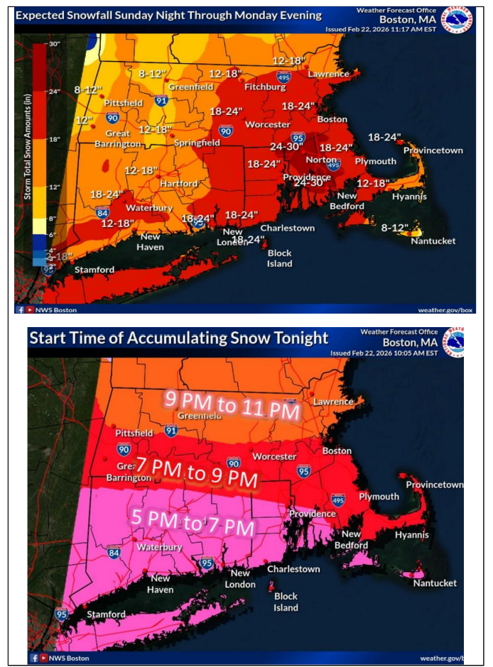
Forecast guidance indicates widespread significant snowfall across Cape Cod:
o Upper Cape: approximately 21–22 inches
o Mid-Cape/Hyannis: approximately 19–20 inches
o Lower Cape: approximately 15–16 inches
o Outer Cape: approximately 12–13 inches (higher totals possible if mixing does not occur)
o Nantucket: Lower snowfall totals expected with potential mixing at times
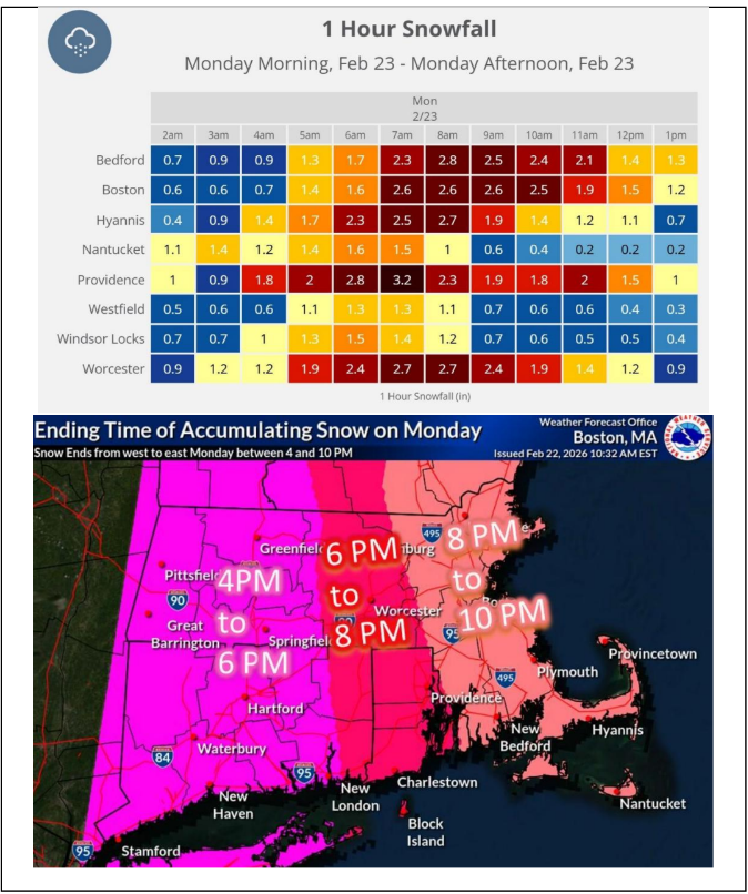
Snow is expected to be heavy, wet, and compacting, increasing the likelihood of tree and powerline damage. Snowfall rates of 3–4 inches per hour are possible during peak storm periods.
Timing and Travel Impacts
o Snow begins early this evening and will intensify overnight.
o Peak blizzard conditions expected approximately 7:00 AM through early afternoon Monday.
o Snow expected to taper Monday evening, with lingering snow showers possible into late evening, especially Outer Cape.
o Visibility may fall below one-quarter mile at times.
o Travel conditions may become difficult to impossible during peak storm conditions Monday.
Wind and Power Impacts
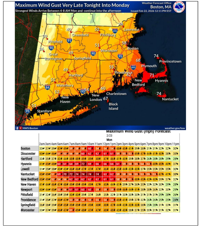
o Wind gusts up to 60–75 mph possible, with isolated hurricane-force gusts along exposed coastal areas.
o Sustained winds near 35 mph will support blizzard conditions.
o Heavy wet snow combined with strong winds significantly increases risk of downed trees and power lines.
o Utilities anticipate scattered to potentially widespread outages.
o Restoration in hardest-hit areas may take multiple days depending on damage and safety conditions.
Coastal Impacts
o Moderate coastal flooding possible, particularly on Nantucket during early morning tide cycles.
o Hyannis Harbor may experience moderate flooding during early morning high tide (~4:00 AM).
o Minor flooding and splash-over possible along additional east- and north-facing shorelines Monday afternoon.
o Timing of peak winds relative to high tide will influence severity.
Cold Temperatures
o Temperatures may fall into the teens Tuesday night.
o Gradual warming midweek will aid snowmelt.
Utilities, Health, and Transportation Readiness (Cape Cod & Islands)
Utilities
o Eversource and National Grid have staged crews and resources across Cape Cod and the Islands.
o Utility liaisons are coordinating directly with local emergency managers and the MACC.
o Residents should report outages directly to their utility provider.
Healthcare
o Cape Cod Healthcare facilities will be closed Monday except for hospital operations.
o Elective procedures and outpatient services have been canceled.
o EMS agencies reminded to transport only medically necessary patients.
Transportation
o Steamship Authority suspending service early this evening and will be out of service Monday.
o Cape Cod Regional Transit Authority services will be suspended Monday; transportation to shelters will be provided when safe to do so.
o Local public works and public safety agencies report full readiness for roadway response.
Regional Shelter Update & Sheltering and Vulnerable Populations
oNauset Regional High School (Eastham) will open as a regional shelter at 6:00 PM tonight.
oBarnstable Intermediate School will open as a regional shelter at 8:00 PM tonight.
oAdditional shelters may be opened if needed as conditions evolve.
Residents seeking shelter are encouraged to:
o Bring medications and essential medical supplies
o Inform family or friends of their destination
o Pets are permitted at regional shelters (bring supplies if possible)
o If leaving home due to outages, leaving a porch light on when power returns may help indicate restoration
o Shelters are intended for residents with unsafe conditions, medical needs, or no heat.
o Power loss alone may not require sheltering unless conditions become unsafe.
o Family Table Collaborative is providing food support to shelters.
o American Red Cross and partner agencies are supporting shelter operations and staffing.
o Residents dependent on electricity for medical equipment such as oxygen are encouraged to plan for alternate power or shelter if outages occur.
Multi-Agency Coordination
Barnstable County’s Multi-Agency Coordination Center (MACC) opens at 5:00 PM and remain active overnight and throughout the storm to coordinate regional response, resource requests, and situational awareness.
State coordination actions include:
o State of Emergency declared
o Massachusetts Emergency Operations Center enhanced monitoring tonight and full activation Monday
o National Guard resources activated and staged statewide
o State debris and emergency support resources on standby
All municipal resource requests should be routed through the MACC.
Preparedness and Safety Information
Residents are encouraged to:
o Avoid unnecessary travel during peak storm conditions Monday
o Prepare for potential multi-day power outages
o Charge essential devices and maintain emergency supplies
o Secure outdoor items
o Check on neighbors, older adults, and vulnerable residents
o Monitor official forecasts and emergency information
Community Information and Updates
Many school districts across Cape Cod have announced closures for Monday; residents should check local school district communications for specific updates.
Shelter openings, warming centers, and municipal emergency information will be shared through town channels and regional partners.
Utility providers will issue outage and restoration updates through official channels.
Regional updates will continue through Barnstable County and BCREPC communication platforms.
Stay Informed
For additional information and updated forecasts, see www.weather.gov/boston (National Weather Service Norton) and www.weather.gov/albany (National Weather Service Albany)
Utilize MEMA’s real-time power outage viewer to stay informed about current power outages in your community and region, and across the state, including information from utility companies about restoration times: http://mema.mapsonline.net/public.html
Online Resources/Links
Barnstable County Regional Emergency Planning Facebook page Barnstable County Regional Emergency Planning Committee | Facebook
Barnstable County Regional Emergency Planning Twitter Barnstable County REPC (@bcrepc) / Twitter
Massachusetts Emergency Management Agency www.mass.gov/mema
MEMA Facebook page http://www.facebook.com/MassachusettsEMA
MEMA Twitter @MassEMA
Mass211 www.mass211.org
Federal Emergency Management Agency www.fema.gov
National Weather Service Boston/ Norton, MA www.weather.gov/boston
Weather Graphics