


Coastal Storm Expected to Impact Cape Cod Sunday into Early Next Week
UPDATED Sunday, 10/12/2025, 9:30 AM
A coastal storm is expected to bring strong winds, heavy rain, and possible coastal flooding to Cape Cod and the Islands beginning late morning to early afternoon Sunday October 12, lasting into early next week.
A large area of high pressure over Canada and a developing low off the Southeast U.S. coast is now drifting north just offshore and will influence our weather today through Tuesday. While the exact track remains uncertain, confidence is increasing that the Cape and Islands will experience impacts from this storm.
Expected Impacts
Rain will arrive late morning to early afternoon on Sunday, first along the south coast, then spreading north and west. Showers will intensify this afternoon and tonight. The steadiest rain and strongest winds are expected overnight tonight into late Monday morning, with lingering effects into Tuesday as the storm slowly pulls away.
Water
Along the shoreline, persistent onshore winds and multiple high-tide cycles will promote water “stacking” and rough surf. Minor coastal flooding is likely, especially around the afternoon high tides today (Sunday) and Monday. Expect the usual vulnerable low spots near harbors, inlets, and causeways to see shallow saltwater on roads and in parking areas.
Wind
Wind impacts will build through late day Sunday. Peak gusts near 60 mph are possible overnight into Monday morning. Nantucket and Martha’s Vineyard are under a High Wind Warning; the Mainland Cape remains under a Wind Advisory but could still see 55–60 mph gusts.
Rain
The Cape and Islands are expected to receive rainfall amounts of 2.5–3.0″+, with even higher amounts in some areas.
Key points:
- Timing: Rain fills in 9:00 AM – 10:00 AM along the south coast; peak impacts overnight Sunday to late Monday morning with a gradual improvement heading into Tuesday.
- Wind: Gusts near 60 mph possible Cape & Islands.
- Coastal flooding: Minor (locally moderate) risk during Sunday PM and Monday PM high tides; rough surf and splash over likely.
- Rain: 2.5–3.0″+ Cape/Islands (isolated 4″); 1.5–2″ elsewhere in SE MA.
- Uncertainty: The Tuesday exit speed of the storm remains uncertain, which could extend wind/rain duration.
What You Can Do
- Secure outdoor items (trash bins, patio furniture, decorations) to prevent debris wash-downs that block storm drains.
- Clear storm drains of leaves and debris near your property to reduce flooding.
- Charge devices and prepare for possible power outages.
- Avoid driving through flooded roadways.
- Plan around high tides Sunday PM and Monday (AM & PM); avoid parking in low-lying waterfront lots, and do not drive through saltwater on roads.
- Move vehicles and elevate items from basements/first floors in flood-prone zones.
- Give yourself extra commute time in coastal neighborhoods; some roads may have shallow saltwater or be closed.
- Report what you see: Use the MyCoast app to share photos of coastal flooding and beach erosion. This helps local and state partners document impacts.
Follow Barnstable County Regional Emergency Planning Committee (BCREPC) and NWS Boston for updated alerts and watches.
Images


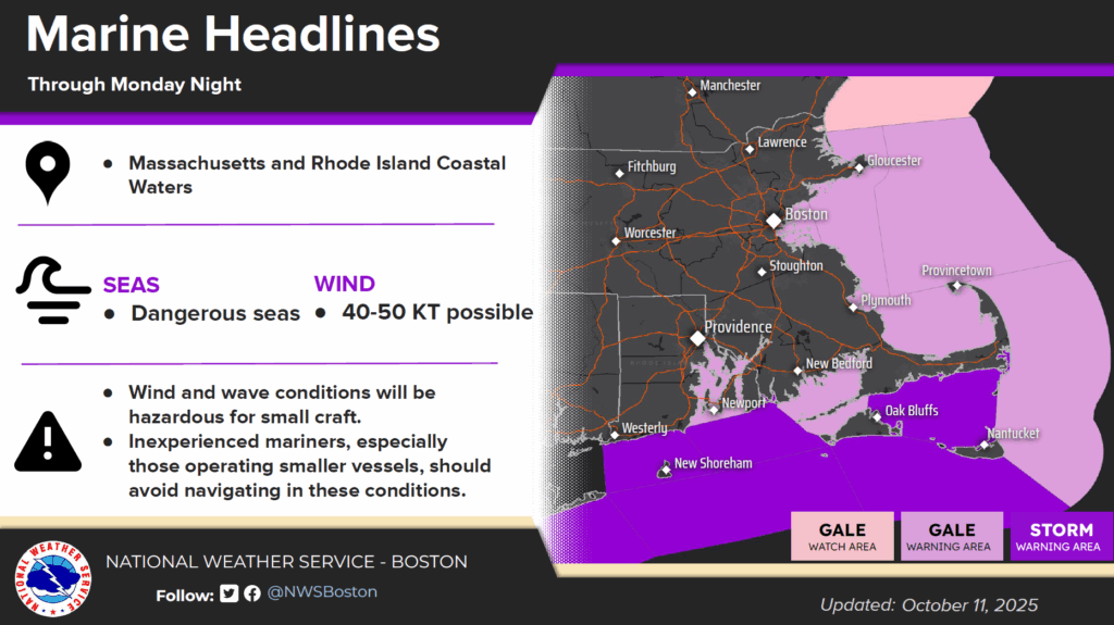


Check back here for updates!
Related: Nor’easter Season is Here: How to Prepare on Cape Cod – Barnstable County