

Cape and Islands Winter Storm Forecast and Readiness Update | 3:00 PM | January 30, 2026
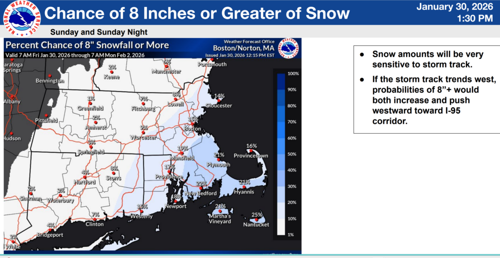
The Barnstable County Regional Emergency Planning Committee met today at 3:00 PM to review the latest winter storm forecast and discuss regional readiness for Cape Cod and the Islands. The call focused on a coastal storm expected Sunday into Sunday night that is currently forecast to track mainly offshore, with the most likely impacts centered on the Cape and Islands. Forecast conditions remain sensitive to storm track, and impacts may change as new guidance becomes available.

Storm Overview
According to the National Weather Service Boston/Norton and the Massachusetts Emergency Management Agency (MEMA), confidence has increased that the storm will remain largely offshore. Even so, Cape Cod and the Islands may still experience accumulating snow, strong winds, hazardous marine conditions, and minor to moderate coastal flooding, particularly in typically vulnerable locations.
Snow and Timing
Snow may begin very early Sunday morning, with the steadiest snowfall most likely during the day Sunday and conditions improving Sunday evening into Sunday night. MEMA reports a potential snowfall range of 2–6 inches for the outer Cape and Islands, noting that small shifts in storm track could significantly change totals.
Wind Impacts
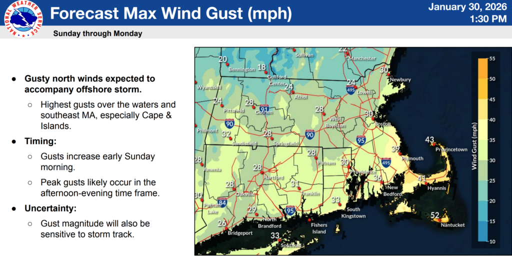
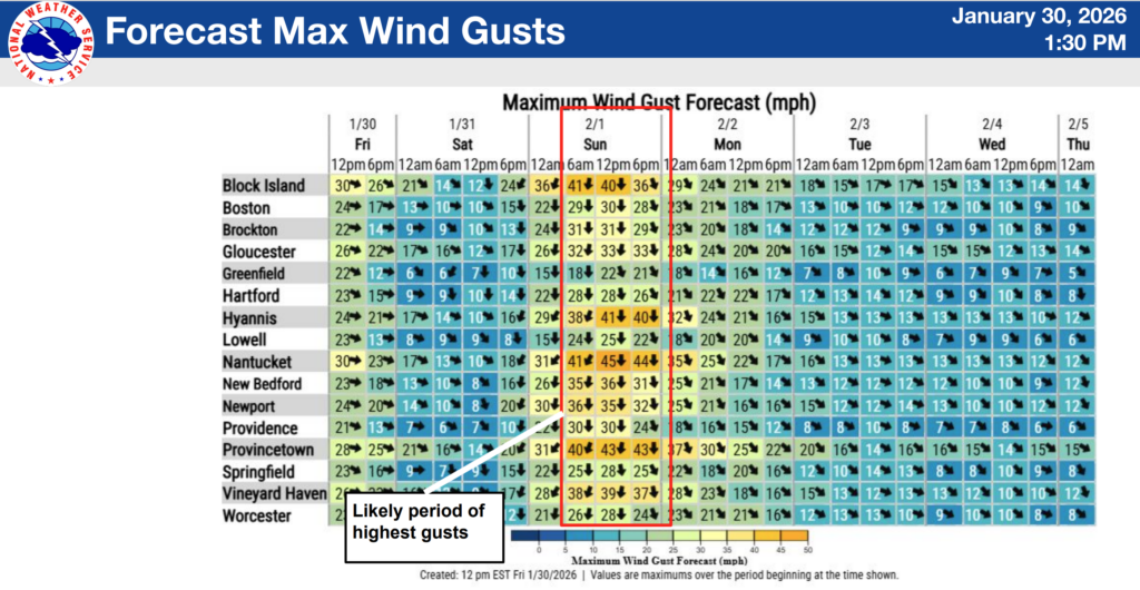
Gusty north winds are expected to develop early Sunday. MEMA indicates wind gusts of 45–55 mph are possible on the outer Cape and Islands, with the strongest winds most likely between Sunday morning and late Sunday night, depending on storm track.
Coastal Flooding and Marine Conditions
There is the potential for minor to moderate coastal flooding around high tides Sunday into Monday, especially in locations that typically experience flooding with northerly winds. MEMA notes isolated areas of moderate flooding may be possible on Nantucket. Marine conditions are expected to be hazardous, with gale-force winds and offshore seas reaching 20 to 25 feet.
Cold Weather and Safety Precautions
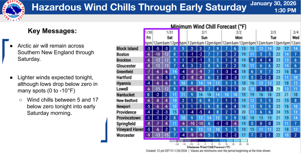
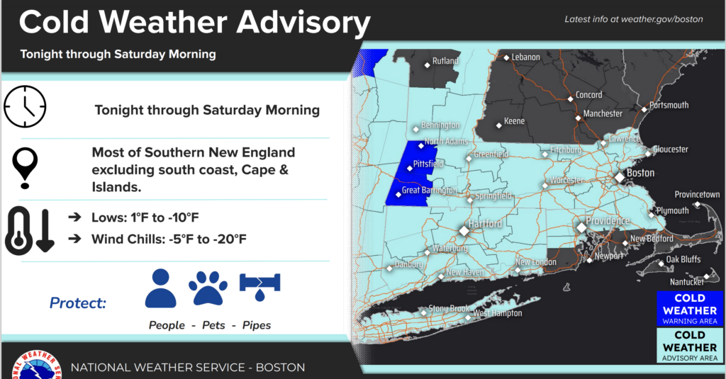
Dangerous cold remains a primary concern. Arctic air will persist through Saturday, with below-zero wind chills overnight, followed by very cold temperatures after the storm passes. Early Monday morning temperatures on Cape Cod are expected to be in the upper teens to near 20°F, with colder conditions inland. MEMA warns that wind chills at these levels can cause frostbite on exposed skin in as little as 30 minutes. NW
Residents are encouraged to take precautions for people, pets, and pipes. Limit time outdoors, dress in warm layers, check on vulnerable neighbors, bring pets indoors or ensure adequate shelter, and protect exposed plumbing by allowing a slow drip and maintaining indoor heat.
Regional Readiness
Regional partners from emergency management, public safety, utilities, healthcare, transportation, human services, and volunteer organizations participated in the call and reported they are poised and ready to respond if conditions change.
Residents are encouraged to continue monitoring weather updates. Follow BCRECP on social media.