
[February 24, 2022 – 4:30 AM | Friday Winter Storm Update from NWS Boston
Published on: February 24, 2022
-
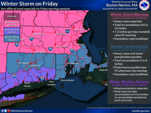
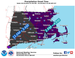
Precipitation likely starts off as a period of moderate to heavy snow during the pre-dawn hours on Friday morning, then likely changes to a wintry mix south of the Mass Pike.
-
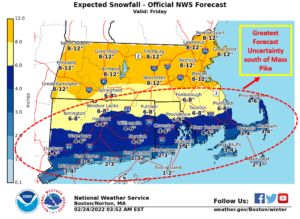
8-12 inches of snow north of the Pike, 4-8 inches south of the Pike, 3-6 inches of snow/sleet along the south coast into Cape Cod.
-
Flash freeze potential for southeast MA and RI late in the day.
|
||||
|
||||
|
||||
|
||||
[su_table]
| Timing |
|
| Hazards/Impact |
|
| NWS Alerts |
|
| Forecast Challenges |
|
| Post-event Outlook |
|
| Next NWS Briefing |
|
[/su_table]
![]()
| MEMA Operations |
| The State Emergency Operations Center (SEOC) is operating at Level 1 (Steady State Monitoring). MEMA will continue to monitor the situation and will disseminate additional Situational Awareness Statements (SAS), as necessary. The next SAS will be issued later this afternoon. |
| Preparedness and Safety Information |
|
| Stay Informed |
| For additional information and updated forecasts, see www.weather.gov/boston (National Weather Service Norton) and www.weather.gov/albany (National Weather Service Albany) Utilize MEMA’s real-time power outage viewer to stay informed about current power outages in your community and region, and across the state, including information from utility companies about restoration times: http://mema.mapsonline.net/public.html |
| Online Resources |
| Massachusetts Emergency Management Agency www.mass.gov/mema MEMA’s Facebook page http://www.facebook.com/MassachusettsEMA MEMA Twitter @MassEMA Federal Emergency Management Agency www.fema.gov National Weather Service Boston/ Norton, MA www.weather.gov/boston National Weather Service/Albany, NY www.weather.gov/albany National Weather Service Weather Prediction Center www.wpc.ncep.noaa.gov National Weather Service Storm Prediction Center www.spc.noaa.gov Northeast River Forecast Center www.weather.gov/nerfc/ National Hurricane Center www.nhc.noaa.gov Mass211 www.mass211.org |