
[3:30 PM] July 7, 2021 | BCREPC Continues to Monitor Tropical Storm Elsa
Incident or Event Overview
Situation
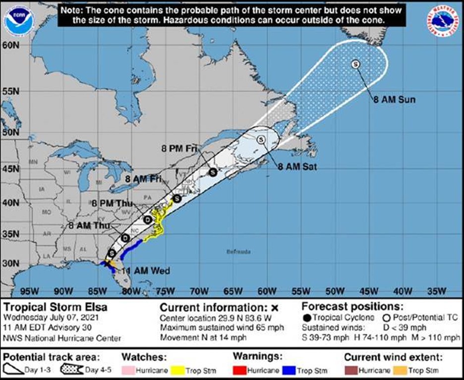
At 11:00am, Tropical storm Elsa was located 65 miles north-northwest of Cedar Key, Florida with 65 mph maximum sustained winds and a minimum central pressure of 999 mb. Elsa is moving north near 14 mph and will continue to move inland. There is still some uncertainty regarding Elsa’s exact track and intensity however [su_highlight]Elsa is expected to pass over southeast New England around dawn on Friday July 9th.[/su_highlight] The National Weather Services’ (NWS) confidence is increasing that this will be a lower-end tropical storm for our area.
The primary concerns with this tropical storm are heavy rainfall to the north and west of where it tracks, strong winds south and east of the track, rough marine conditions, and an increase in surf and rip currents along south coastal areas. No coastal or storm surge flooding is expected.
Elsa is expected to be a fast-moving storm clearing out of MA by early Friday evening.
Impacts/ Potential Impacts
- Potential for gusty winds up to 35 mph. Greatest risk in eastern Massachusetts
- Heavy rainfall of 2 to 3+ inches with the greatest threat in central/western Massachusetts
- Heavy rainfall could lead to isolated flash flooding and urban flooding.
- Dangerous marine conditions across coastal waters, especially around the south of the Cape and Islands. Potential for rough surf and rip currents, especially along the south coast.
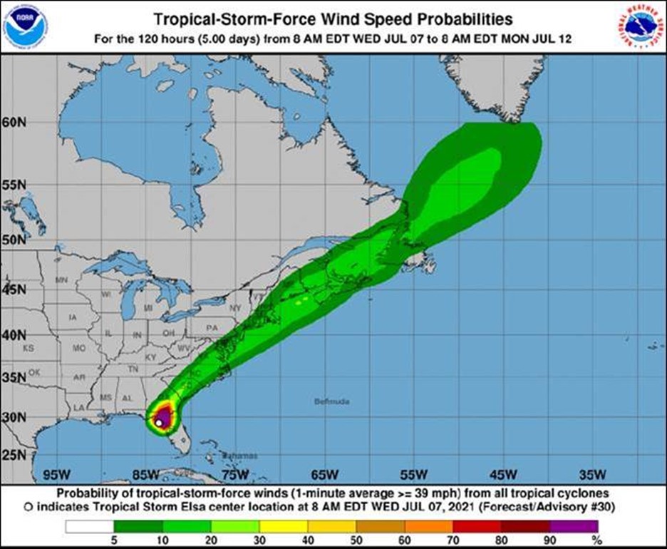
Tropical Storm Winds Probabilities:
· Boston: 12%
· Nantucket: 15%
Tropical Storm Elsa Overview:
· Still uncertainty with regard to exact track and intensity as Elsa makes its closest approach on Friday.
· Low confidence in aspects of forecasts for wind, rainfall, and wave heights.
Wind Speed and Probabilities:
· Roughly 1 in 10 chance of winds reaching tropical storm force (40 mph sustained) across the Cape and Islands.
· Roughly 1 in 20 chance of tropical storm force winds for Southeast Massachusetts.
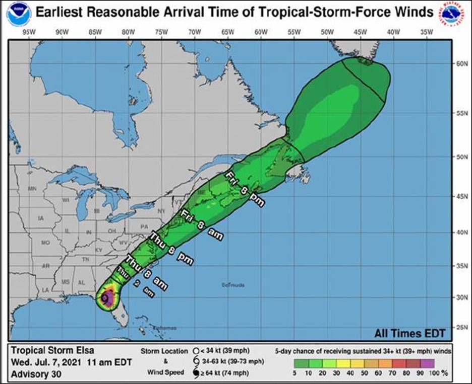
Earliest Reasonable Time of Arrival:
· The earliest reasonable time of arrival of tropical storm force winds, could be around dawn Friday July 9th.
· Period of strongest winds will only be about 6 hours.
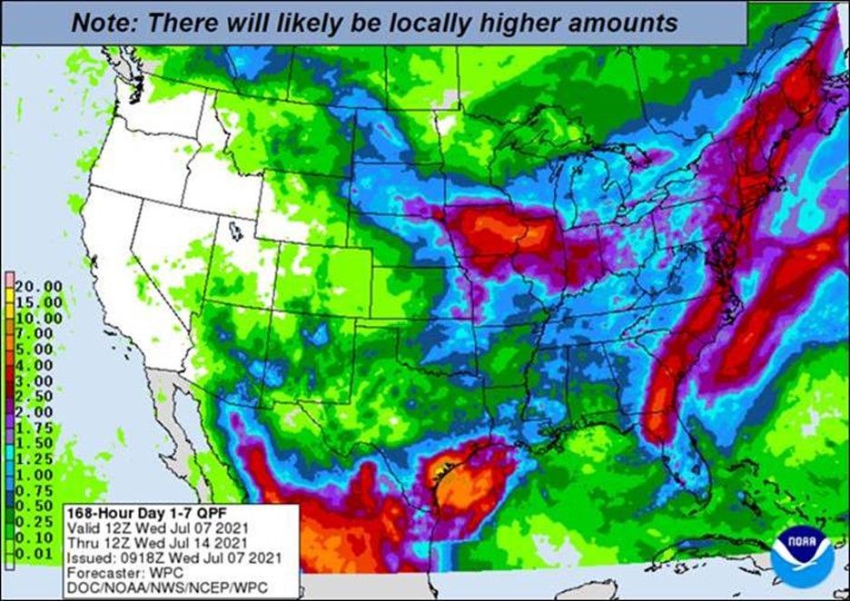
Expected Total Rainfall:
· Elsa could produce 2-3 inches of rain, primarily to the northwest of the storm track. Greatest risk area is Central and Western Massachusetts.
· Map below shows the 7-day total rainfall through July 14th.
· Total shown on map includes expected rainfall from thunderstorms today and Thursday prior to Elsa’s closets approach.
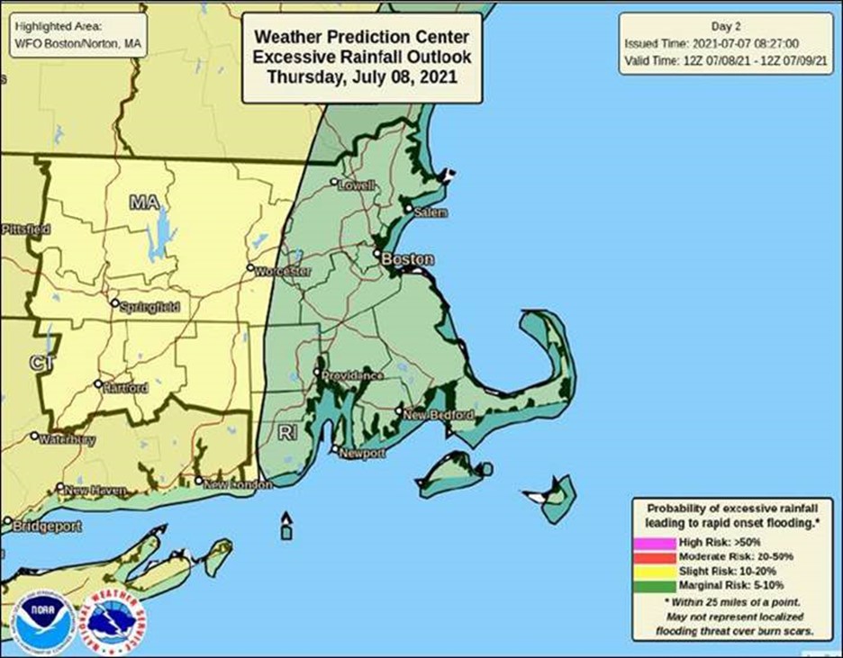
Excessive Rainfall Outlook:
· The below map shows that western portions of southern New England are in a “Slight Risk” for
excessive rainfall through Thursday night. Additional rain is likely Friday morning.
MEMA Operations
MEMA is coordinating daily conference calls with NWS, Emergency Support Function (ESF) partners, and local and state officials to discuss the forecast for Tropical Storm Elsa, potential impacts, and state/local preparedness actions.
The State Emergency Operations Center (SEOC) is currently operating at Level 1 (Steady State Monitoring). MEMA will continue to monitor the situation and will disseminate additional Situational Awareness Statements, as necessary. The next SAS will be issued tomorrow morning.
[su_box title=”Preparedness and Safety Information ” box_color=”#0099cb”]
Preparedness and safety tips for tropical storms and hurricanes: https://www.mass.gov/info-details/hurricane-safety-tips
Power outage preparedness and safety information: https://www.mass.gov/info-details/power-outage-safety-tips
Preparedness and safety tips for thunderstorms and lightning: https://www.mass.gov/info-details/thunderstorm-and-lightning-safety-tips
Flood safety tips: https://www.mass.gov/info-details/flood-safety-tips[/su_box]
[su_box title=”Stay Informed” box_color=”#0099cb”]
For additional information and updated forecasts, see www.weather.gov/boston (National Weather Service Norton) and www.weather.gov/albany (National Weather Service Albany)
Utilize MEMA’s real-time power outage viewer to stay informed about current power outages in your community and region, and across the state, including information from utility companies about restoration times: http://mema.mapsonline.net/public.html
[/su_box]
[su_box title=”Online Resources” box_color=”#0099cb”]Massachusetts Emergency Management Agency www.mass.gov/mema
MEMA’s Facebook page http://www.facebook.com/MassachusettsEMA
MEMA Twitter @MassEMA
Federal Emergency Management Agency www.fema.gov
National Weather Service Boston/ Norton, MA www.weather.gov/boston
National Weather Service/Albany, NY www.weather.gov/albany
National Weather Service Weather Prediction Center www.wpc.ncep.noaa.gov National Weather Service Storm Prediction Center www.spc.noaa.gov
Northeast River Forecast Center www.weather.gov/nerfc/National Hurricane Center www.nhc.noaa.gov
Mass211 www.mass211.org [/su_box]
