Hurricane Lee: Situational Report #002
Date of Release: Friday, September 15, 2023
Time of release: 12:30 PM
Incident or Event Overview
Situation
The BCREPC held a storm coordination meeting Friday, September 15th at 10:00 AM to discuss potential impacts to Cape Cod and the Islands from the approaching Hurricane Lee, as well as local preparedness measures and resources being mobilized at this time.
It is anticipated that the MACC will open Saturday morning at approximately 5:00 AM. Equipment and resources have been put in place and staff are on standby for activation.
The next BCREPC meetings will take place Saturday 9/16 at 10:00 AM. The previously scheduled meeting for 4:00 PM today has been cancelled to allow for storm preparations.
Impacts/ Potential Impacts
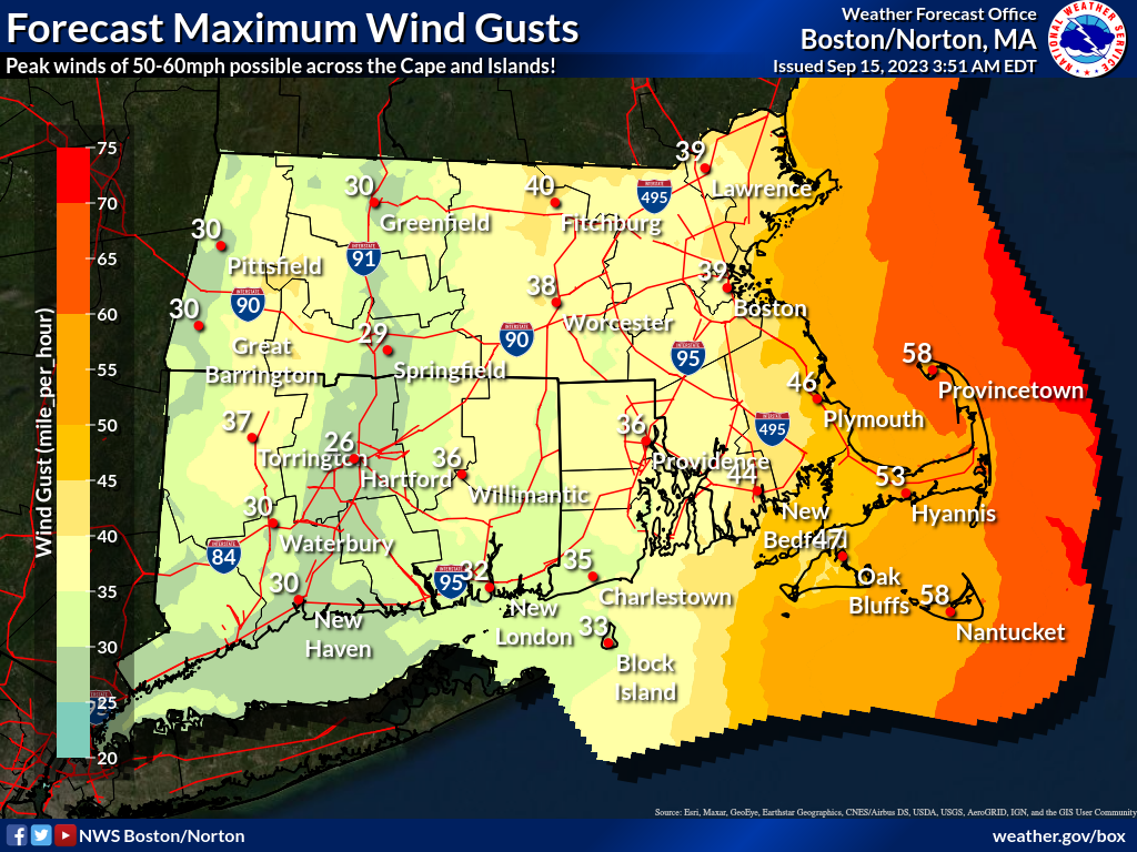
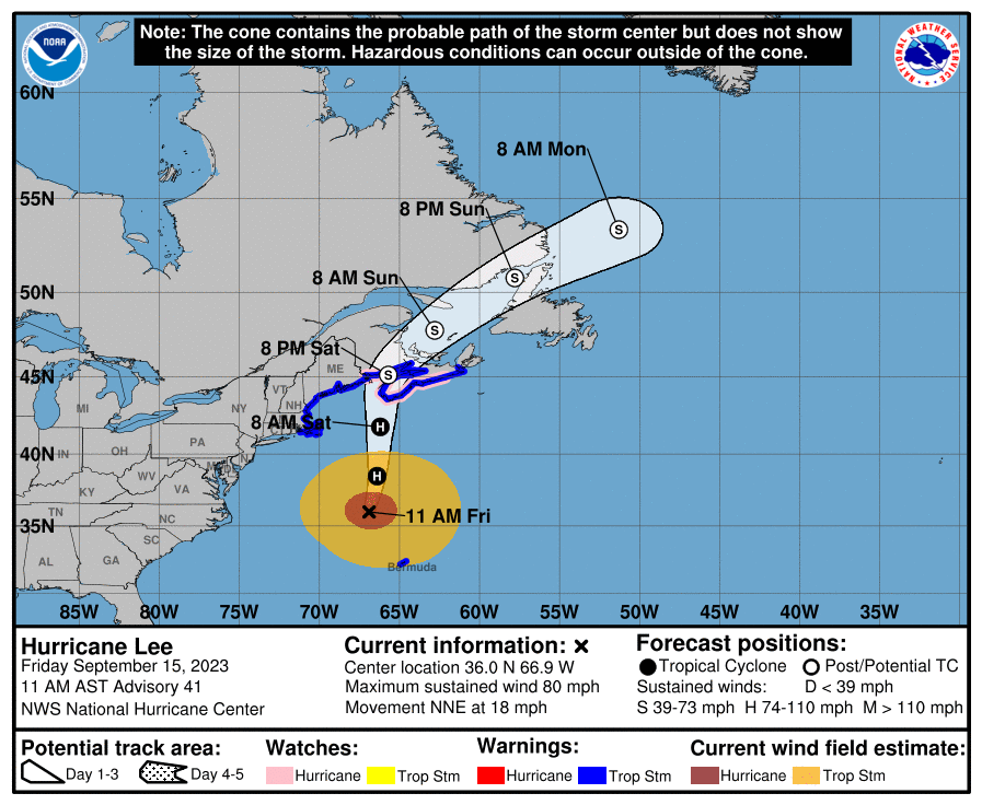
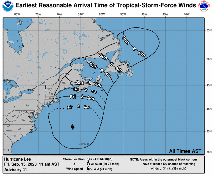
- The forecast and predicted storm impacts remain relatively unchanged apart from timing. Tropical storm force winds (gusts of 40+ mph) are now anticipated to begin closer to 5:00 PM on Friday evening, with peak winds expected early Saturday morning at around 5:00 AM.
- Residents should continue to follow updates and monitor the forecast.
- Peak winds will likely occur offshore of the Outer Cape. Residents Cape-wide should plan for 50 to 60 MPH wind gusts at the storm’s peak. There is low potential for 65-70+ mph wind gusts on the Outer Cape. Winds are expected to drop off significantly into Saturday afternoon/evening.
- 1-2” of rainfall are expected; totals could be slightly higher for the mid- to outer- Cape regions.
- A 1-3ft storm surge is anticipated in relation to the evening high tide. Lee is not expected to induce rapid storm surge; coastal flooding is a more significant concern at this time.
- Coastal flooding is likely in Cape Cod Bay. Wind direction will strongly influence the pattern of coastal flooding and will be watched closely as the storm approaches.
- Dangerous surf and rip currents are anticipated with this storm.
- Storm impacts are expected to taper off tomorrow afternoon by 2/3:00 PM.
Updates from Agencies/Utilities
Eversource:
- A Type 3 ERP will begin Friday at 6pm (this status prepares preemptively for 140K outages state-wide at storm peak with full restoration completed 72 hours after the storm has passed).
- Opening 4 EOC’s in eastern MA; a full liaison schedule is in place as a contingency in case there is a need to deploy in the Cape towns. Regular emergency updates are being provided to local emergency officials.
- An Eversource representative will be embedded in the MACC starting Saturday at 6:00 AM.
National Grid: Crews/resources in place and on standby.
Verizon: Crews/resources in place and on standby.
Regional Shelter Update
The BCREPC is prepared for post-impact sheltering. Coordination is taking place across shelter partners (Americorps, MRC, Red Cross, Salvation Army) and all shelter personnel are standing by. There are no plans for shelter openings pre-storm.
Weather Forecast Overview
Advisories, Watches, and Warnings
- Tropical Storm Warning: WWA Summary for Tropical Storm Warning Issued by BOX (weather.gov)
- Coastal Flood Warning: WWA Summary by Location for 41.74N 70.43W with MAZ022/MAC001/MAZ022 emphasis Coastal Flood Warning (weather.gov)
- Hurricane Local Statement: WWA Summary by Location for 41.74N 70.43W with MAZ022/MAC001/MAZ022 emphasis Hurricane Local Statement (weather.gov)
- High Surf Advisory: WWA Summary by Location for 41.74N 70.43W with MAZ022/MAC001/MAZ022 emphasis High Surf Advisory (weather.gov)
MEMA Operations
- The State Emergency Operations Center (SEOC) will be operational 7:00 AM to 7:00 PM starting Saturday morning (9/16).
- A MEMA liaison will be deployed to the Barnstable County MACC when it activates.
- MEMA will continue to monitor the situation and will disseminate additional Situational Awareness Statements (SAS) as necessary (cadence for this storm is 8:00 AM and 6:00 PM).
- There are currently no plans to activate the emergency traffic plan or sheltering at Joint Base Cape Cod.
- Next briefing Friday at 3:00 PM.
Preparedness and Safety Information
- The Coast Guard has requested that people remove their kayaks and canoes from the water to a safe and secure location. It is also recommended that, if possible, people remove their larger trailerable boats from the water as well.
- Residents in potential flood zones should take pictures of their homes and surrounding areas for insurance purposes in the event of water damage. Check Storm Tide Pathways Project (stormtides.org) for determination of flood risk.
Stay Informed
For additional information and updated forecasts, see www.weather.gov/boston (National Weather Service Norton) and www.weather.gov/albany (National Weather Service Albany).
Utilize MEMA’s real-time power outage viewer to stay informed about current power outages in your community and region, and across the state, including information from utility companies about restoration times: http://mema.mapsonline.net/public.html .
Online Resources/Links
- Barnstable County Regional Emergency Planning webpage Emergency Planning Committee Archive – Barnstable County (capecod.gov)
- Barnstable County Regional Emergency Planning Facebook page Barnstable County Regional Emergency Planning Committee | Facebook
- Barnstable County Regional Emergency Planning Twitter Barnstable County REPC (@bcrepc) / Twitter
- Barnstable County Main Facebook Barnstable County Government | Facebook
- Barnstable County Main Twitter Barnstable County Government (@CapeCodGov) / Twitter
- Barnstable County Main Website Home – Barnstable County (capecod.gov)
- Massachusetts Emergency Management Agency www.mass.gov/mema
- MEMA Facebook page http://www.facebook.com/MassachusettsEMA
- MEMA Twitter @MassEMA
- Mass211 www.mass211.org
- Federal Emergency Management Agency www.fema.gov
- National Weather Service Boston/ Norton, MA www.weather.gov/boston
- National Weather Service/Albany, NY www.weather.gov/albany
- National Weather Service Weather Prediction Center www.wpc.ncep.noaa.gov
- National Weather Service Storm Prediction Center www.spc.noaa.gov
- Northeast River Forecast Center www.weather.gov/nerfc/
- National Hurricane Center www.nhc.noaa.gov
- Steamship Authority | The Steamship Authority