[January 27, 2022 | 5:30 PM ] Winter Storm-Late Friday Night Through Saturday Night – MEMA Situational Awareness Statement #2
Situation
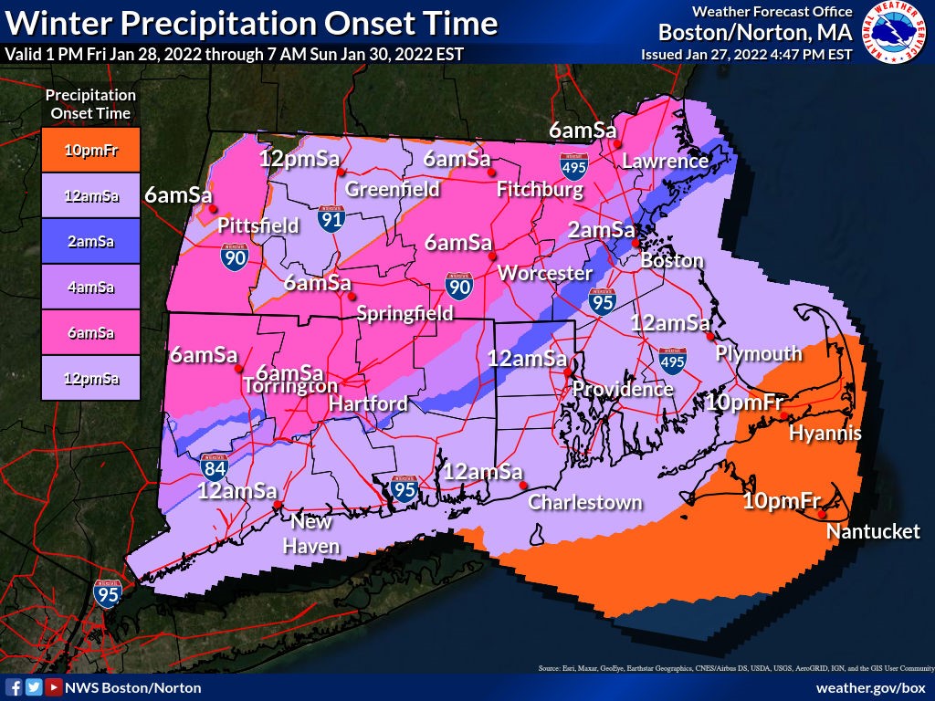
The National Weather Service (NWS) has a high degree of confidence that a strong storm forecast to develop off the East Coast by this weekend will grow into a Nor’easter, bringing heavy snow, strong winds, and minor to pockets of moderate coastal flooding to parts of Massachusetts. The NWS anticipates the storm will move into New England late Friday night and will intensify overnight into Saturday. Snowfall will continue through the day, becoming heavy Saturday afternoon, before tapering off in the evening.
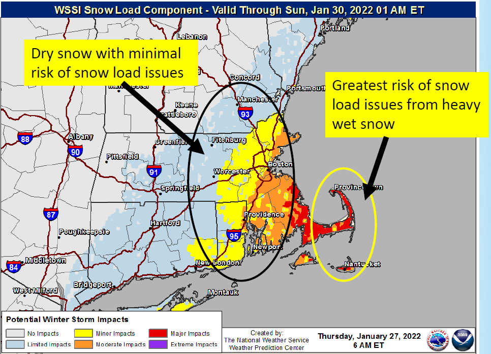
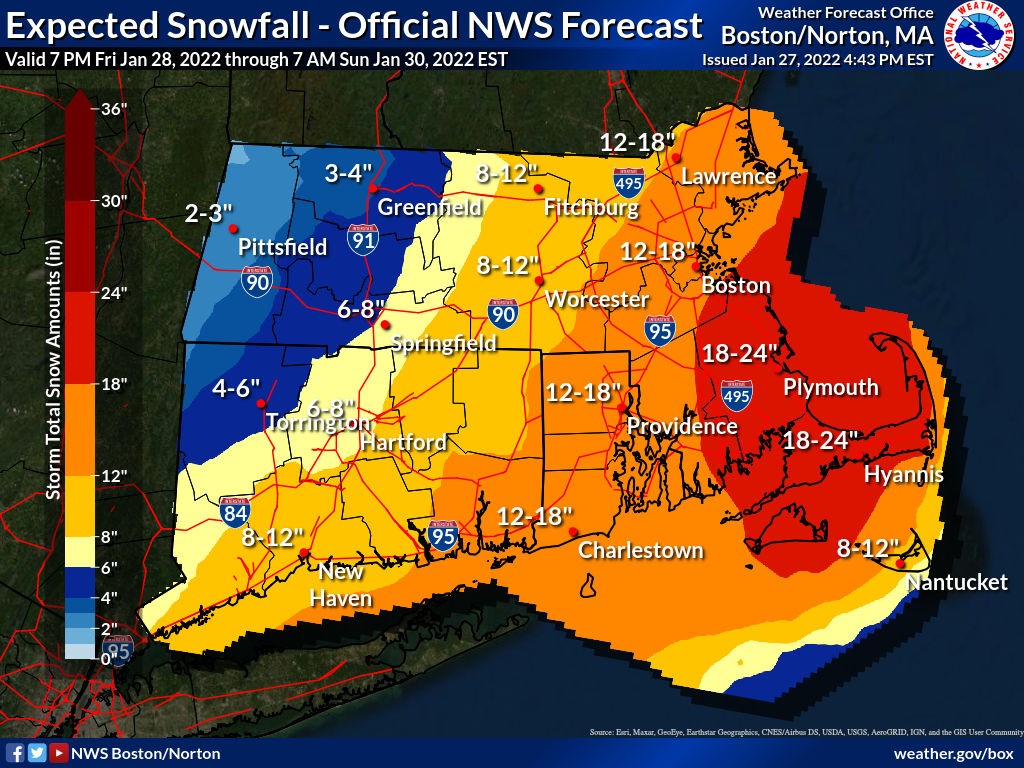
The area of heaviest snowfall will hinge on the exact track of the storm system which remains uncertain. Based on the current forecast, the area of greatest risk is southeastern MA and the Cape and Islands where as much as 18”- 24” of snow is expected. 12”- 18” is expected in the I-95 corridor and the North Shore and 8”- 12” in central MA. In Western MA, areas east of I-91 can expect 4”- 8”, and areas further west can expect 3”- 6”. Snow is expected to be powdery and dry over most of the state but wetter and heavier on the Cape and Islands, especially the Outer Cape and Nantucket.
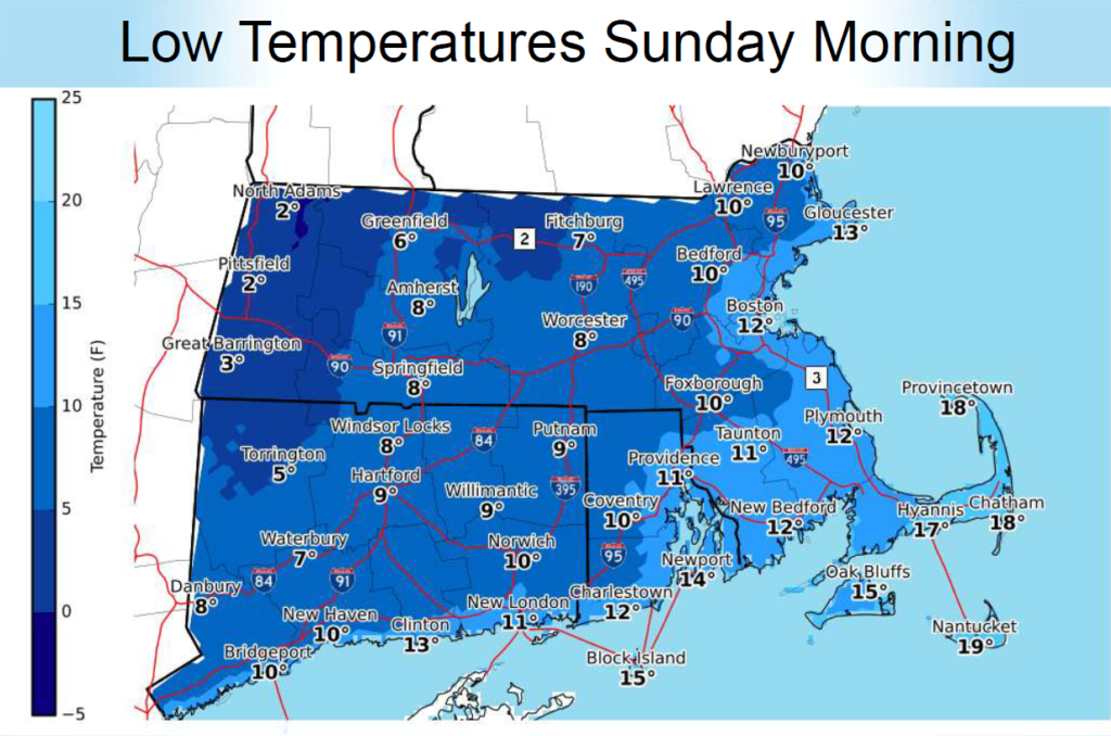
Temperatures will be very cold in the wake of the storm with wind chills remaining at or below zero into Sunday.
Impacts/ Potential Impacts
- Hazardous travel:
- Snowfall, blowing, and drifting snow is expected late Friday night into Saturday night and will cause decreased visibility and hazardous travel conditions. Near-blizzard conditions are possible Saturday afternoon across southeastern MA and the Cape and Islands.
- Power outages and wind damage:
- Strong winds, combined with the weight of heavy snow, may down trees and power lines, leading to power outages.
- Accumulations of heavy wet snow on roofs may result in structural damage, especially on the Outer Cape and Nantucket.
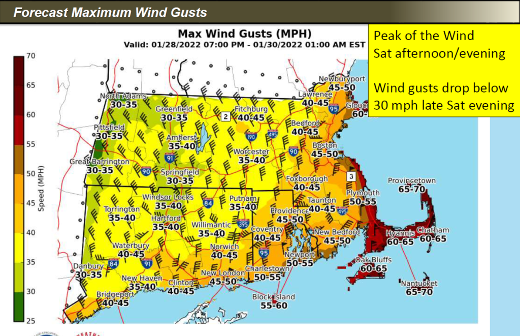
- Winds are expected to be strong on Saturday, especially during the afternoon and evening. Eastern MA will be at the greatest risk. Strong northeast wind gusts of 50 MPH are expected with the possibility of wind gusts of 60 MPH or higher for the Cape and Islands.
- Coastal flooding:
- Minor coastal flooding (inundation of less than one foot above ground level). Localized moderate coastal flooding (inundation of 1 to 2 feet above ground level) is possible.
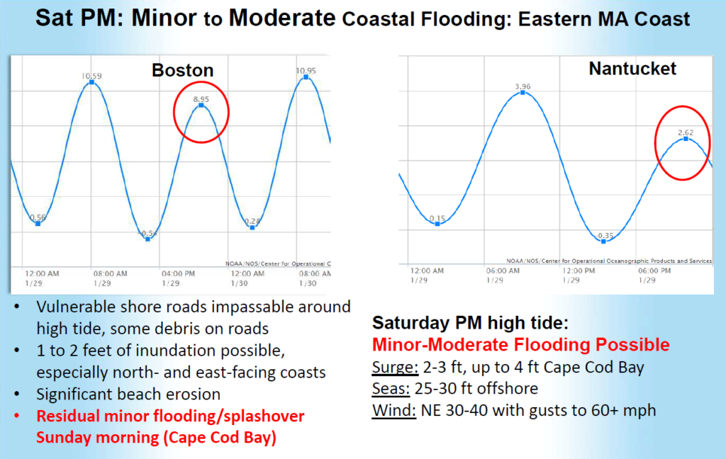
- The high tide of concern is Saturday evening when a 2–4-foot storm surge (4 feet being a “worst-case” scenario) is expected.
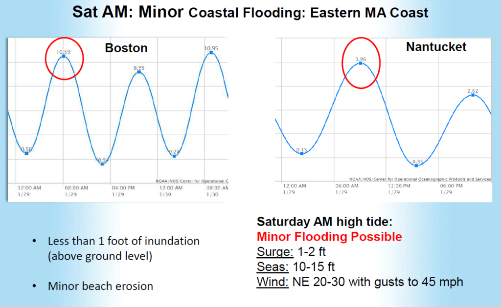
- Saturday morning: Minor flooding (surge of 1 to 2 feet with seas of 10-15 ft). NE winds 20 to 30 mph with gusts to 45 mph.
- Saturday evening: Minor flooding with pockets of moderate flooding occurring in more vulnerable areas such as Plum Island, Scituate, and the shore of Cape Cod Bay from Sandwich to Dennis (surge of 2 to 4 feet with seas near 30 ft). Significant beach erosion. NE winds 30 to 40 mph with gusts to 60+ mph.
- Rough surf along the coast may lead to debris on coastal roadways, especially during the Saturday evening high tide.
Sunday morning: Residual minor flooding and splash over are possible, especially in Cape Cod Bay.
Weather Forecast Overview
Advisories, Watches, and Warnings – Last updated: 15:20 EST on 01-27-2022
| Winter Storm Watch Issued: January 27 at 3:20 PM EST Expiring: January 30 at 12:00AM EST |
|
| Areas affected: Eastern Franklin; Eastern Hampden; Eastern Hampshire | |
| Winter Storm Watch Issued: January 27 at 3:20 PM EST Expiring: January 30 at 12:00AM EST |
|||||||
Areas affected: Northern Worcester; Northwest Middlesex County; Southern Worcester
|
|||||||
Electric Distribution Company (EDC) plans and preparations:
Eversource:
- Eversource is planning for a high-level Type 4 ERP event or a low-level Type 3 ERP event
- Formal ERP declaration expected tomorrow morning (Friday)
- For a Type 3 ERP event
- Restoration activities are generally accomplished within a 72 hour period; and
- Typically up to 10% (130,000) customer interruptions
- Opening all 5 EOCs:
- Boston;
- Southboro;
- Yarmouth;
- Springfield; and
- New Bedford.
- Secured additional, external crews;
- Pre-staging additional line and tree crews on the Cape and Martha’s Vineyard (Friday morning);
- Municipal Officials have been receiving storm planning updates from the Community Liaison organization; and
- Notified all life support customers and communities to prepare for the event (Thursday).
National Grid:
- Declaring a Type 3 ERP event as of 5 pm Thursday;
- Restoration activities are generally accomplished within a 72 hour period; and
- Typically up to 10% (up to 130,000) customer interruptions.
- Opening storm rooms at 10 pm Friday:
- Brockton;
- Hopedale;
- Worcester;
- North Andover; and
- Malden.
- Secured additional, external contract crews;
- Pre-staging crews on Nantucket (Friday);
- Strategically pre-staging transmission crews near the Hull H1/H2 line; and
- Life support and critical facility outbound calls will be performed Friday.
Until:
- Monitoring weather forecast;
- Conducting internal storm planning logistics meetings;
- Issued Public Service Announcement on Thursday alerting customers to be prepared for the storm; and
- Not expecting a significant impact.
MEMA Operations |
| The State Emergency Operations Center (SEOC) is operating at Level 1 (Steady State Monitoring). MEMA will continue to monitor the situation and will disseminate additional Situational Awareness Statements (SAS), as necessary. The next SAS will be issued tomorrow morning.
MEMA is hosting daily statewide coordination calls with NWS, local municipal officials, and Emergency Support Function Team members to provide updated weather briefings and discuss preparedness actions for the upcoming storm. |
| MEMA Region Updates | ||
| MEMA East (Regions 1 and 2) | Critical Issues |
|
| Unmet Needs | None reported. | |
| MEMA West (Regions 3 and 4) | Critical Issues | None reported. |
| Unmet Needs | None reported. | |
Preparedness and Safety Information |
Additional preparedness and safety information:
|
Stay Informed |
| For additional information and updated forecasts, see www.weather.gov/boston (National Weather Service Norton) and www.weather.gov/albany (National Weather Service Albany)
Utilize MEMA’s real-time power outage viewer to stay informed about current power outages in your community and region, and across the state, including information from utility companies about restoration times: http://mema.mapsonline.net/public.html |
Online Resources |
| Massachusetts Emergency Management Agency www.mass.gov/mema MEMA’s Facebook page http://www.facebook.com/MassachusettsEMA MEMA Twitter @MassEMA Federal Emergency Management Agency www.fema.gov National Weather Service Boston/ Norton, MA www.weather.gov/boston National Weather Service/Albany, NY www.weather.gov/albany National Weather Service Weather Prediction Center www.wpc.ncep.noaa.gov National Weather Service Storm Prediction Center www.spc.noaa.gov Northeast River Forecast Center www.weather.gov/nerfc/ National Hurricane Center www.nhc.noaa.gov Mass211 www.mass211.org |