[UPDATED 01-28-22 – 7:00 AM ]Intense high impact coastal storm will pound southern New England late tonight through Saturday with snow and prolonged damaging winds
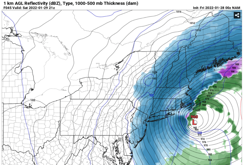
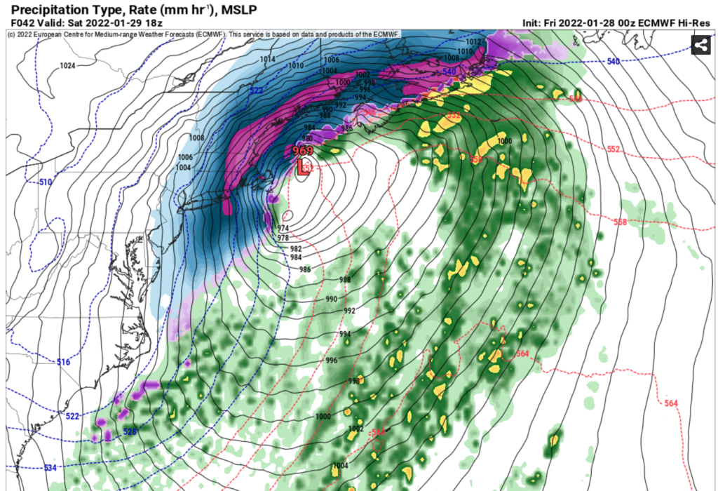
Low pressure will move up the eastern US coast tonight and Saturday passing south of Cape Cod
Discussion and Forecast
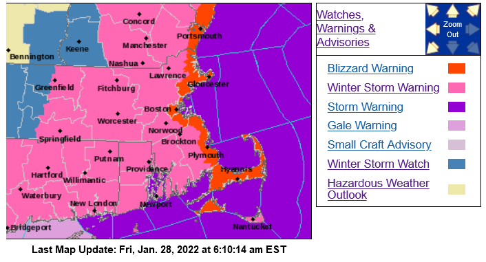
A Blizzard Warning is in effect for all of east coastal MA including Cape Cod and Martha’s Vineyard. A winter storm warning is in effect for the rest of MA except western sections. Guidance now essentially locked in for an intense coastal storm to pound southern New England late tonight through Saturday with winds near hurricane force along parts of the coast, coastal flooding, and very heavy snow. Low pressure along the SE US states will begin moving up the east coast late tonight. The intense surface low will likely pass near or just south of the 40N 70W Benchmark position for northeast storms.
Snow should break out just after midnight in southern New England and begin to become more steady in the hours towards 4:00-5:00 am. By 6:00-7:00 am heavier snow will likely be in progress with increasing winds during the morning. Travel could become difficult from any time after 5:00-6:00 am. The snow will become much heavier as the morning progresses with peak periods of heavy snow moving through the area from late morning until early afternoon. As the afternoon progresses, the heaviest intense bands of snow will affect the region into the Saturday night period with some bands having near 2 inches per hour snowfall rates. Some even stronger bands could occur with near 3+ inches per hour snowfall rates at times. Snowfall should begin to taper down Saturday night near or before midnight.
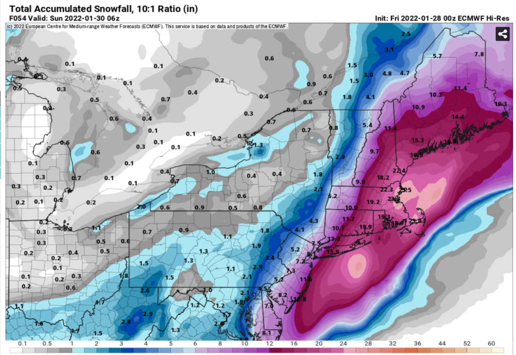
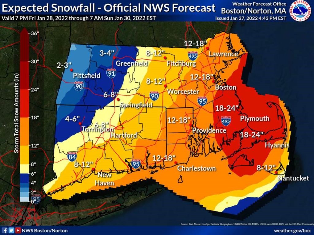
Snowfall totals should be quite high in much of southern New England. Western sections of MA should see around 4-8”. In central MA to near the 495 zone, a swath of 8-12” amounts with some 14-16” amounts are likely. From the 495 zone to Boston, NE MA, and the I95 corridor, 14-20” looks likely with some higher amounts as we get near SE MA. From the south shore into the remainder of SE MA including much of Cape Cod, amounts of 18-24” are possible with localized amounts of 24-28” possible in parts of extreme SE MA that are near any intense banding. There could be a bit of sleet mixing in on the lower and outer Cape holding down accumulations to 14-18”. Even Nantucket may see amounts of 8-14”.
Damaging winds will rake a good part of eastern MA on Saturday. Winds in western sections of MA could be gusting over 40-45mph at times. In central MA, winds gusts near 50mph are likely. In eastern MA, including Boston and NE MA away from the coast, wind gusts over 60-65mph are possible. In the coastal section near Cape Ann, winds over 70mph are possible. In coastal sections of SE MA, wind gusts to over 70mph are possible with some gusts to near hurricane force. Winds will be strongest over the Cape and Islands and will gust over 70-75mph with some gusts to 80+mph on the outer parts of the Cape and Nantucket.
Water will begin piling up offshore on Saturday. We are expecting minor coastal flooding at the early morning Saturday high tide. The greatest threat will be the evening high tide for considerable amounts of moderate coastal flooding along east and northeast facing coastal sections. There could be a few locations that get into higher-end moderate coastal flooding.
These hazards will present a significant chance for power outages, especially near the lower and outer Cape where the snow will be of the heaviest consistency at times. Travel may become almost impossible in parts of eastern and SE MA, including parts of Cape Cod during Saturday afternoon.
Extended outlook
It will be windy and colder into the teens on Sunday morning. A moderating trend will continue next week with high temperatures in the upper 40s by midweek.
Frank O’Laughlin
Meteorologist