[January 14, 2022 – 9:30 AM] Multiple Winter Weather Impacts Forecast through This Weekend
The following information is taken from the Massachusetts Emergency Management Agency Situation Report #2
Overview
The National Weather Service (NWS) is forecasting multiple winter weather impacts to impact the New England region starting today and continuing through the weekend into early next week.
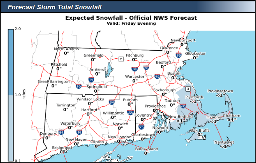
Rain will begin falling this morning across southeastern Massachusetts and the Cape and Islands, changing over to a brief period of snow during the afternoon and evening. Light snowfall will end west of Hyannis by 8-9 PM, but ocean effect snow showers may linger across the Outer Cape into Saturday morning. Snowfall totals less than 1” in southeastern Massachusetts are possible from this event. Additionally, temperatures will begin falling sharply on Friday afternoon, causing wet surfaces or slush to rapidly freeze and become icy, especially in the Plymouth/Hyannis area.
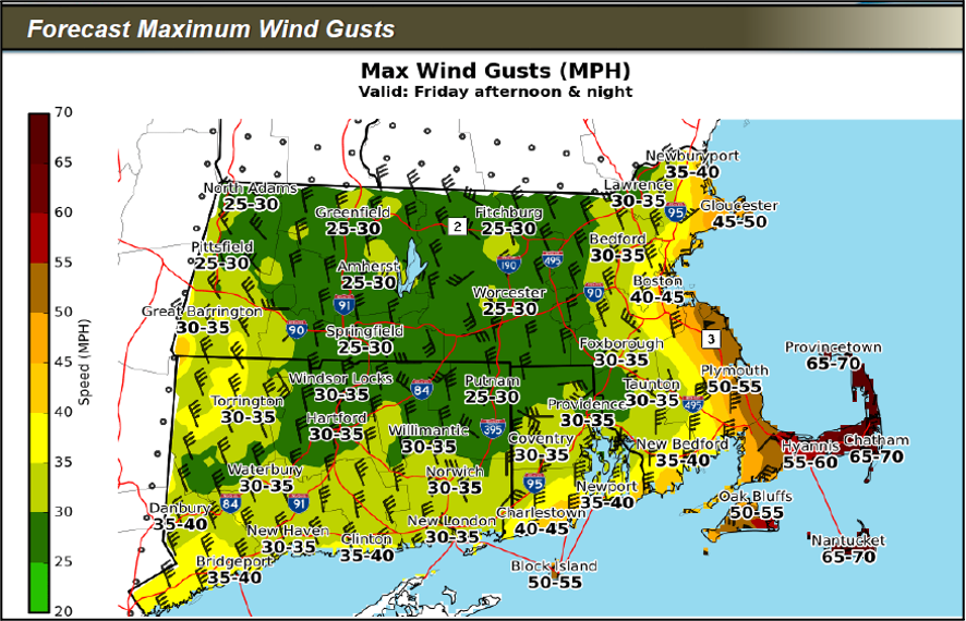
Winds will begin to pick up across the region starting Friday afternoon, with the strongest winds expected between 4 PM and midnight. 50-55 MPH wind gusts are possible in southeastern coastal MA and 60-70 MPH gusts across the Outer Cape and Nantucket.
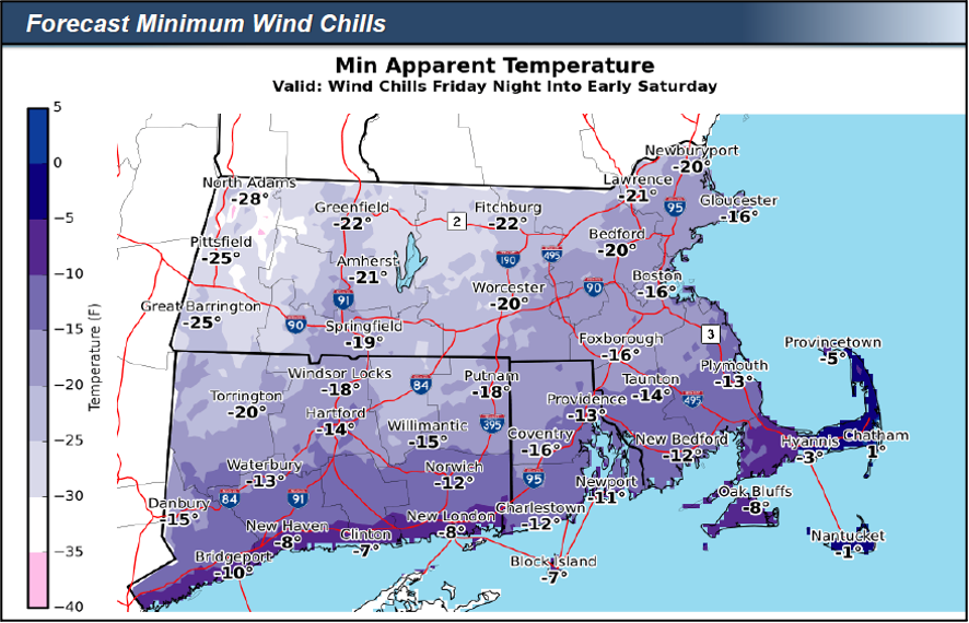
The combination of falling temperatures and gusty winds will result in bitterly cold wind chills of 15-30 degrees below zero late Friday into early Saturday.
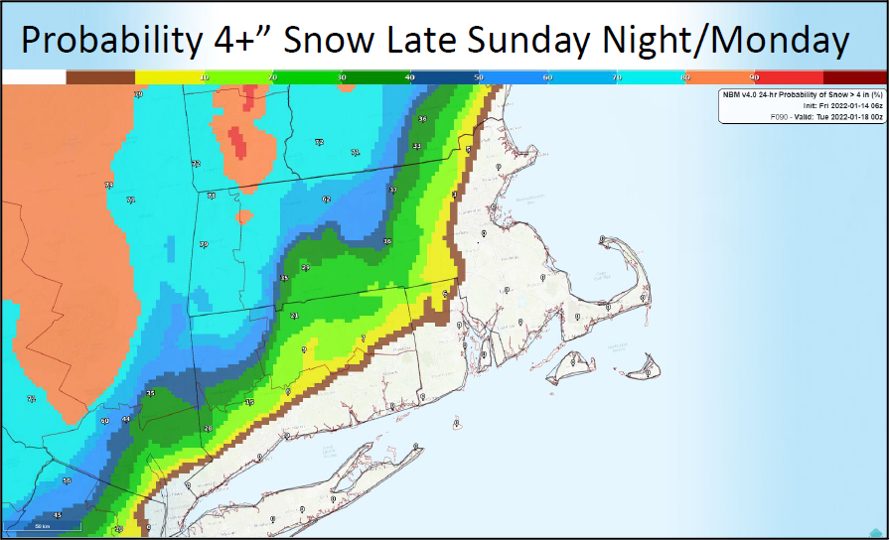
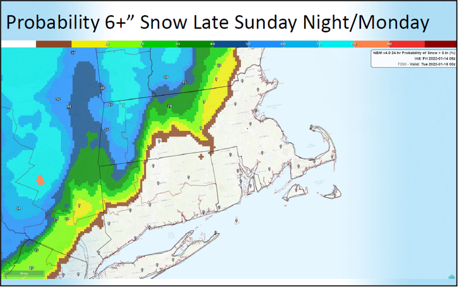
Starting late Sunday night and continuing into Monday, another strong storm is forecast to impact New England. This storm is still several days away and changes to its track are possible, but if it follows the current forecast track, the areas at risk of 6” or more of snow are western and central Massachusetts before a changeover to rain. Precipitation is likely to remain all rain along and southeast of the Boston – Providence corridor, but a brief burst of snow is possible at the onset. If the storm tracks further east than forecast, the axis of heaviest snowfall could shift eastward into the Boston-Providence corridor.
Potential Impacts
- Sharply falling temperatures Friday afternoon in southeastern Massachusetts will cause wet surfaces or slush to rapidly freeze and become icy, resulting in hazardous travel conditions. The Friday evening commute may be impacted.
- Strong winds on Friday may blow down trees and power lines and cause hazardous travel conditions for high profile vehicles.
- Dangerously cold wind chills Friday night and Saturday morning could cause frostbite to exposed skin in as little as 10 minutes. Persons outside during this time should wear appropriate clothing, a hat, and gloves.
- Heavy snow may affect the Monday morning commute in western and central Massachusetts.
|
|||||||||||||||||||||||||||||||
Critical Information
- Electric utilities will be in enhanced operations and will continue to monitor the situation.
- External crews have been secured and will be pre-staged on the Cape and Islands.
Preparedness Information
- Safety and preparedness tips for nor’easters and coastal storms: https://www.mass.gov/info-details/noreaster-coastal-storm-safety-tips
- Safety and preparedness tips for extreme cold:
https://www.mass.gov/info-details/extreme-cold-safety-tips - Winter storm preparedness and safety information:
https://www.mass.gov/info-details/winter-storm-safety-tips - Safe winter driving tips:
https://www.mass.gov/winter-weather-driving - Winter safety tips for pets:
https://www.mass.gov/service-details/winter-pet-safety-tips - Power outage preparedness and safety information:
https://www.mass.gov/info-details/power-outage-safety-tips
Stay Informed
For additional information and updated forecasts, see www.weather.gov/boston (National Weather Service Norton) and www.weather.gov/albany (National Weather Service Albany)
Utilize MEMA’s real-time power outage viewer to stay informed about current power outages in your community and region, and across the state, including information from utility companies about restoration times: http://mema.mapsonline.net/public.html
Online Resources
Massachusetts Emergency Management Agency www.mass.gov/mema
MEMA’s Facebook page http://www.facebook.com/MassachusettsEMA
MEMA Twitter @MassEMA
Federal Emergency Management Agency www.fema.gov
National Weather Service Boston/ Norton, MA www.weather.gov/boston
National Weather Service/Albany, NY www.weather.gov/albany
National Weather Service Weather Prediction Center www.wpc.ncep.noaa.gov
National Weather Service Storm Prediction Center www.spc.noaa.gov
Northeast River Forecast Center www.weather.gov/nerfc/
National Hurricane Center www.nhc.noaa.gov
Mass211 www.mass211.org