[UPDATED 01-26-22 – 6:20 pm ] Intense high impact coastal storm will likely affect southern New England Friday night and Saturday
Confidence continues to increase in a significant impact on the region. Low pressure will form off the southeast US coast Friday morning and begin to move up the coast on Friday night. Impacts are expected near midnight on Friday, with the system departing on Saturday evening.
A winter storm watch has been posted for much of eastern MA from Metro west eastward. The Watch does not include Nantucket due to some mixing from a warmer marine air layer holding down accumulations.
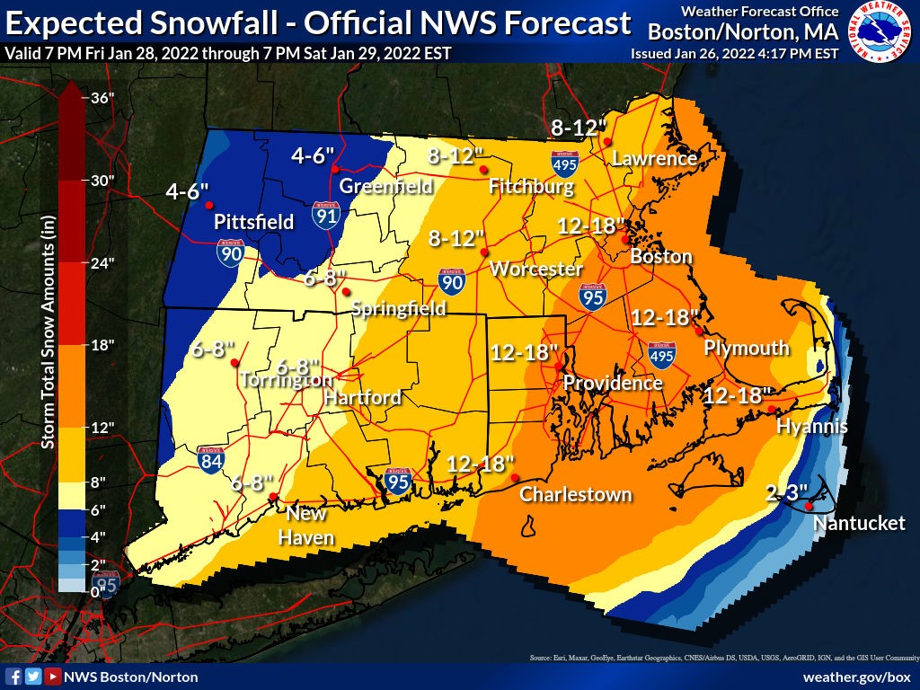
Hazards with this system include heavy snow, damaging winds, and coastal flooding. Snowfall will be highly dependent on the track of the surface low. Most of the best guidance suites calling for the surface low to pass near or over the benchmark position for northeast storms (40N 70W). Possible snowfall up to a foot in eastern MA with the highest amounts near 16-18” in far southeast MA and the Cape. Amounts drop off below a foot as we get near central MA into western MA.
With a near 970mb low bombing out off the coast, a very strong pressure gradient will lead to very strong winds. Winds gusts of 55mph are possible in eastern MA, with winds near 60mph in southeast MA. As we get into extreme SE MA and the Cape and Islands, including the south coast, winds of 65-70mph are possible. Higher gusts could occur over the lower and outer Cape, including Nantucket. In NE MA, winds over 60mph are likely, with gusts near 40mph in western MA.
Tides will be astronomically high as we near the end of the month on Saturday. A strong NE wind over a large fetch could produce some moderate coastal flooding at high tide along east and northeast facing coastal sections.
All of the above effects are highly dependent on the ultimate track of the surface low. The heaviest snow max will move further north into the I95 zone with a mix holding down accumulations over the Cape if the low comes closer. If the low is further out, much lesser snow amounts will occur in the I95 zone with most of the heavy snow over mainly the Cape, but possibly less than the current forecast due to further south placement of the snow shield. It will likely be Thursday afternoon before enough real confidence in snow amounts can be realized.
Report provided by: Frank O’Laughlin, Meteorologist