[10/26/21 – Tuesday AM] High Wind Warning and Storm Warning in Effect for Cape & Islands
Intense coastal storm expected in Southern New England today and Wednesday with very heavy rain, coastal flooding, and very strong winds
Synopsis
A digging trough over the east coast will transfer energy from one low to a new low approaching southern New England tonight.
Discussion and Forecast
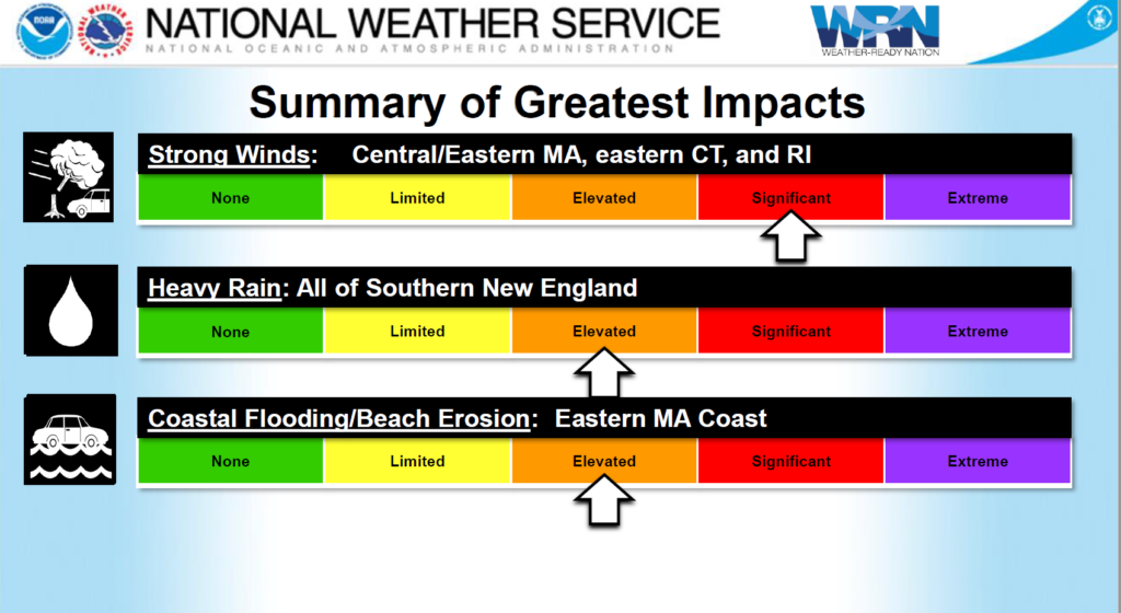
A new rapidly intensifying surface low will approach Southern New England tonight as it loops south of the region and slowly spins itself down as it exits the area on Thursday. Guidance has had a difficult time with the exact placement of the surface low, but the most consensus is it will be drawn in from SE of New England looping south of the region and exiting on Thursday. This system will bring three essential hazards today through Wednesday. Those are heavy rain, damaging winds, and minor coastal flooding.
The exact axis of the precipitation is still difficult to determine with real precision, even at this late hour. The best consensus is the heaviest precipitation in southern New England will be in eastern MA. 3-4” rainfall expected from near the south coast up through NE MA including Boston and Metro West. A bit less for the Cape and Islands near 3” or so, but this is speculative at best. Any convective activity could also offer up localized higher amounts. Lesser amounts are indicated in central and western MA, but flash flood watches are still up as it would not take much rain to initiate flooding.
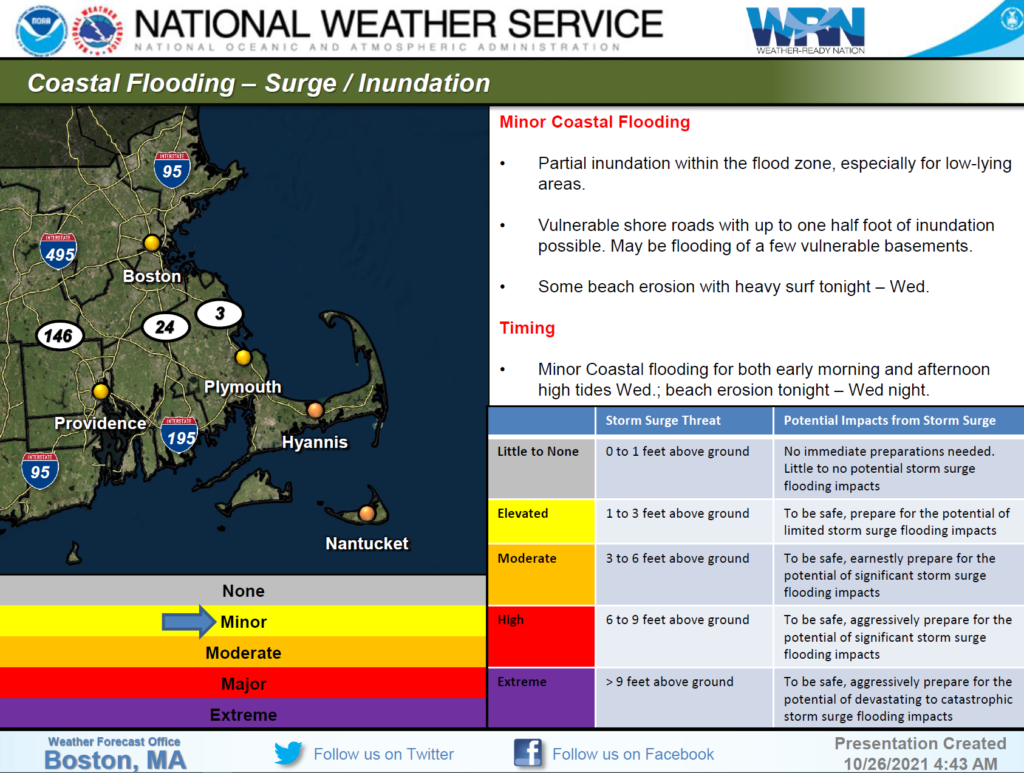
With a persistent NE fetch over a long duration of time, water will pile up along north and east-facing coastal beaches, despite being at low astronomical high tides. With the persistent wind fetch, it is harder for water to go out during low tide. This increases the high tide when the water comes back in on the next cycle. The main concerns are the early Wednesday morning tide and the afternoon Wednesday times as they will coincide with the strongest winds. Surge values of 1-3 feet are likely, but fortunately, Astro tides a quite low so only minor coastal flooding is anticipated.
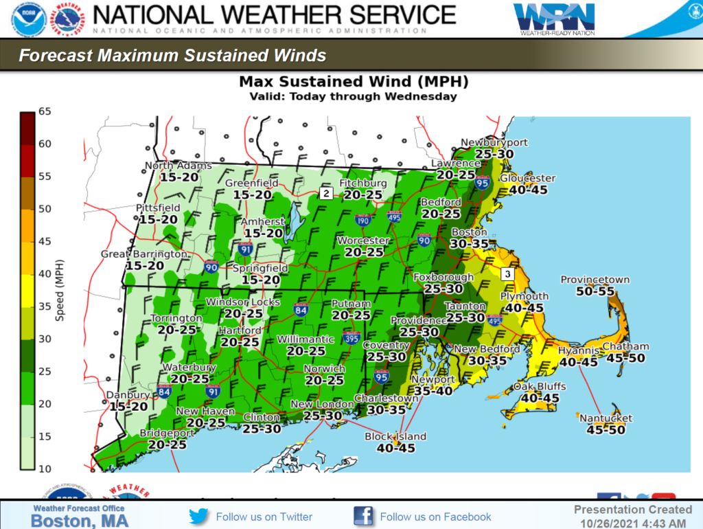
The greatest threat from this system will be the wind. Intense low pressure in the mid 970mb range will combine with a strong 1030mb high to the north to create a very strong pressure gradient. Low-level jet over southern New England will likely produce wind gusts to near 75mph on the outer Cape from Ptown down to the lower Cape near Chatham. 65-70mph gusts are possible for the rest of the Cape/Islands. Winds will really ramp up this afternoon as we get after 2-3 pm and will be roaring all night into Wednesday afternoon when we should see the max low-level jet exiting the region very slowly. A high wind warning is up for all of eastern MA. 60-70mph winds are possible all along the east coast of MA. With many areas still with leafed-out vegetation (especially along with the south coast/Cape/Islands), power outage potential will be increased. We should start to see a slow ramp-down of the winds after Wednesday afternoon.
Frank O’Laughlin, Meteorologist
| Preparedness and Safety Information |
|
| Stay Informed |
| For additional information and updated forecasts, see www.weather.gov/boston (National Weather Service Norton) and www.weather.gov/albany (National Weather Service Albany)
Utilize MEMA’s real-time power outage viewer to stay informed about current power outages in your community and region, and across the state, including information from utility companies about restoration times: http://mema.mapsonline.net/public.html |
| Online Resources |
| Massachusetts Emergency Management Agency www.mass.gov/mema MEMA’s Facebook page http://www.facebook.com/MassachusettsEMA MEMA Twitter @MassEMA Federal Emergency Management Agency www.fema.gov National Weather Service Boston/ Norton, MA www.weather.gov/boston National Weather Service/Albany, NY www.weather.gov/albany National Weather Service Weather Prediction Center www.wpc.ncep.noaa.gov National Weather Service Storm Prediction Center www.spc.noaa.gov National Hurricane Center www.nhc.noaa.gov Mass211 www.mass211.org |