image of barnstable county courthouse

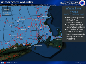
[February 23, 2022 – 4:30 AM | Winter Storm Watch from Midnight Friday to Midnight Saturday

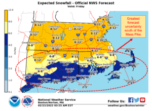
  • A winter storm will bring accumulating snow and ice to Southern New England Friday.
  • Precipitation likely starts off as a period of moderate to heavy snow during the pre-dawn hours, then likely changes to a wintry mix across portions of the region.
  • The greatest risk for 6+ inches of snow north of the Mass Pike.

[su_table]

Timing
  • Beginning Friday pre-dawn hours
  • Tapering off late Friday night/early Saturday morning
Hazards/Impact
  • Friday morning commute will be impacted, and possibly evening commute.
  • Snowfall rates of an inch per hour or greater will be likely for a period of time, possibly coinciding with the Friday morning commute.
NWS Alerts
  • Winter Storm Watch from midnight Friday to midnight Saturday.
Forecast Challenges
  • Uncertainty in timing of changeover from snow to a wintry mix
  • Location of changeover line
  • Uncertainty in timing and location of the second band of snow late in the day
Post-event Outlook
  • Before normal temperatures. Lows mainly 10-20 Friday night.  Highs in the 30s Saturday.  Dry weather expected this weekend.
Next NWS Briefing
  • 5:00 PM Wednesday

[/su_table]

The owner of this website has made a commitment to accessibility and inclusion, please report any problems that you encounter using the contact form on this website. This site uses the WP ADA Compliance Check plugin to enhance accessibility.