
[February 16, 2022 – 3:30 AM | Strong Winds Anticipated Late Thursday to Friday, Heavy Rain and Higher Temps]
Published on: February 16, 2022
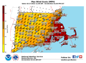
- Strong southerly/southwesterly winds late Thursday night into Friday morning. Widespread gusts 50-60 mph south and east of the I-95 corridor.
- Unseasonably warm temperatures, 50F to 60F, and widespread one inch of rain expected to accompany high winds; rapid melting of snowpack
[su_table]
| Timing | Late Thursday night into Friday morning. The highest winds will be after midnight Friday. |
| Hazards/Impact |
|
| NWS Alerts | High Wind Watches are in effect for SE MA and RI |
| Forecast Challenges |
|
| Post-event Outlook |
|
| Next NWS Briefing | 6 PM |
[/su_table]
