
[January 6, 2022 – 9:30 AM] MEMA WEATHER UPDATE – For the Cape & Islands, west of Hyannis can expect 4- 7” snow, outer Cape and Islands 2-3”.
The Multi-Agency Coordination Center (MACC) is monitoring the weather situation for the Cape and Islands region.
The following report is provided by Massachusetts Emergency Management Agency.
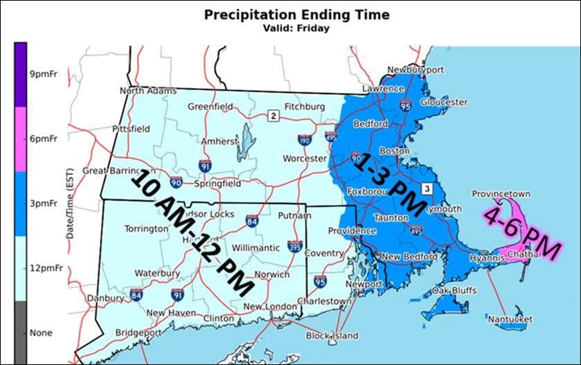
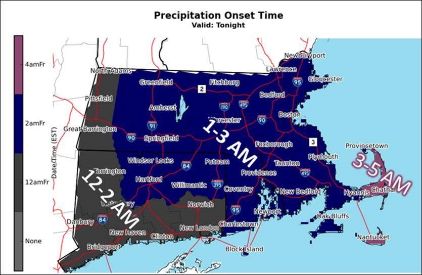
The National Weather Service (NWS) is forecasting a winter storm to impact the state late tonight through Friday afternoon. Snowfall is expected to begin in western and central Massachusetts (MA) between midnight and 2 AM, overspreading the entire state by 5 AM Friday. The heaviest snowfall will occur between 5 and 10 AM Friday morning, with snowfall rates of greater than 1” per hour possible in the I-95 corridor, southeast to near the Cape Cod canal. End timing for this event will vary from 10 AM to 6 PM, west to east, as the storm pulls away Friday.
The NWS has a high degree of confidence in accumulating snow however the westward extent of accumulating snow remains uncertain. Additionally, the axis of the heaviest snowfall may shift.
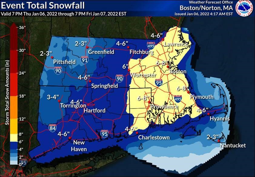
Total snowfall accumulation from this event is forecast to be 2-4” in western MA, 4- 6” in central MA, and 6-8” in eastern MA. For the Cape and Islands, areas west of Hyannis can expect 4- 7”, and the outer Cape and Islands 2-3”.
During the storm, sustained winds are expected to be 10 to15mph with wind gusts of 20 to 25mph.
Dry, cold, and blustery conditions are forecast for Friday night into Saturday.
Impacts/Potential Impacts
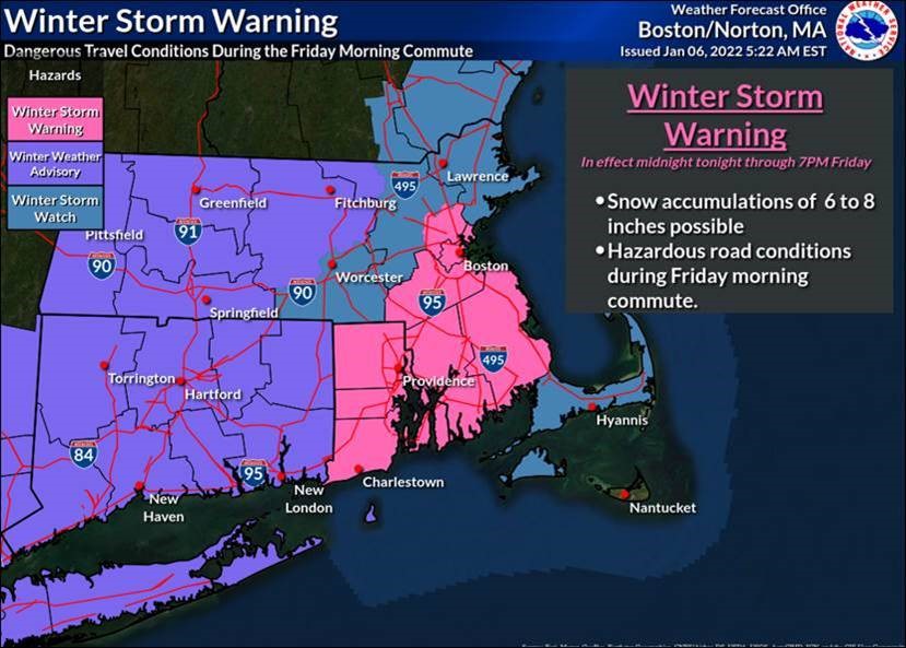
- The combination of snow and reduced visibility will result in hazardous travel impacting the Friday AM commute.
- Temperatures will be cold enough that snow will stick immediately on untreated paved surfaces.
- 1 inch per hour or greater snowfall rates possible along the I-95 corridor, southeast to near the Cape Cod canal.
Advisories, Watches, and Warnings
|
||||||||||||||||||||||||||||||
| The State Emergency Operations Center (SEOC) is operating at Level 1 (Steady State Monitoring). Beginning at 5 AM Friday morning, the SEOC will transition to Level 2 (Enhanced Watch). Additional MEMA staff will be present in the SEOC with liaisons from MassDOT and MA State Police supporting virtually.
MEMA will continue to monitor the situation and will disseminate additional Situational Awareness Statements, as necessary. |
Preparedness and Safety Information |
|
Stay Informed |
| For additional information and updated forecasts, see www.weather.gov/boston (National Weather Service Norton) and www.weather.gov/albany (National Weather Service Albany)
Utilize MEMA’s real-time power outage viewer to stay informed about current power outages in your community and region, and across the state, including information from utility companies about restoration times: http://mema.mapsonline.net/public.html
|
Online Resources |
| Massachusetts Emergency Management Agency www.mass.gov/mema MEMA’s Facebook page http://www.facebook.com/MassachusettsEMA MEMA Twitter @MassEMA Federal Emergency Management Agency www.fema.gov National Weather Service Boston/ Norton, MA www.weather.gov/boston National Weather Service/Albany, NY www.weather.gov/albany National Weather Service Weather Prediction Center www.wpc.ncep.noaa.gov National Weather Service Storm Prediction Center www.spc.noaa.gov Northeast River Forecast Center www.weather.gov/nerfc/ National Hurricane Center www.nhc.noaa.gov Mass211 www.mass211.org |
