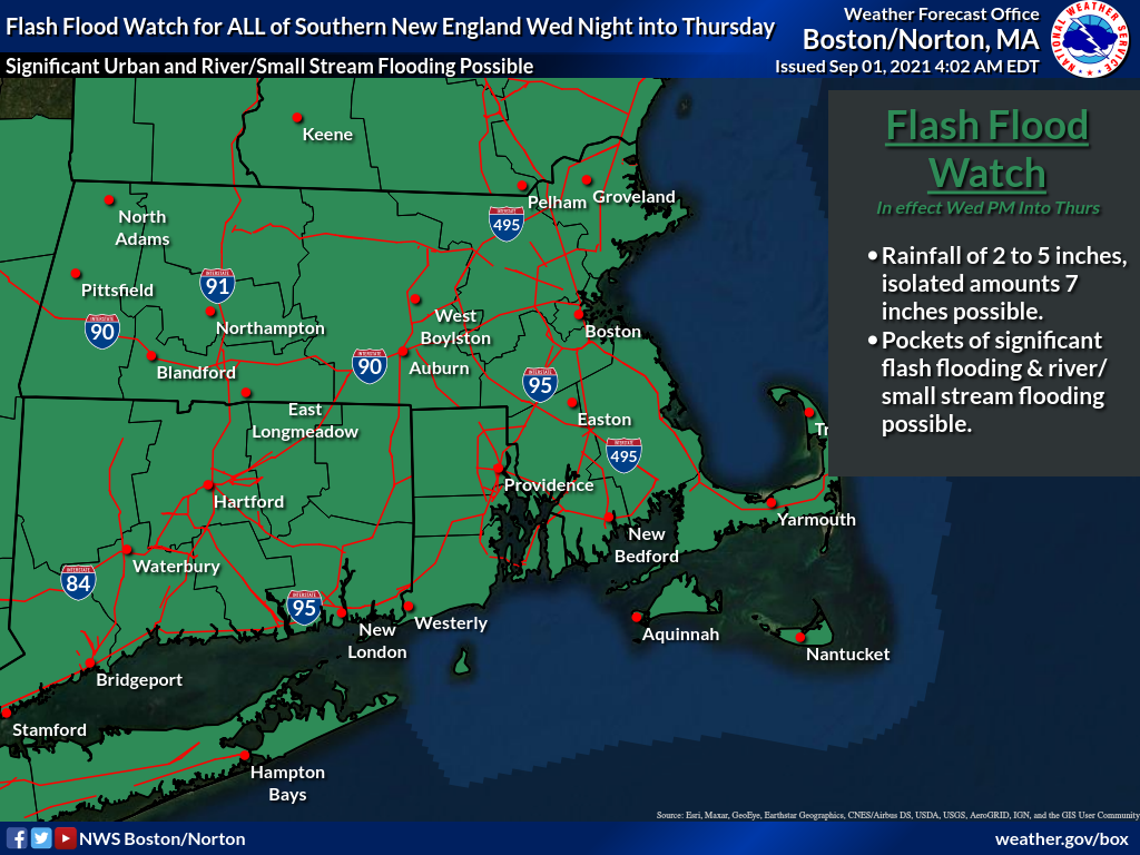
[ 9/01/21 | 4:16 AM] Flash Flood Watch in effect for ALL of CT, MA and RI late tonight into Thursday morning
Published on: September 1, 2021
Discussion and forecast
Extreme rainfall with significant flooding is possible late tonight into Thursday morning.
Flash Flood Watch in effect for ALL of CT, MA and RI this afternoon through Thursday afternoon.
- The remnants of Ida will approach the southern New England area today. Our region may experience a few showers early by noon, but the bulk of the heavy rain will likely be from late afternoon through Thursday morning.
- Many of the guidance suites have shifted the axis of the heaviest rain into the area near or just south of the MA Pike with lesser amounts on the south coast and Cape/Islands.
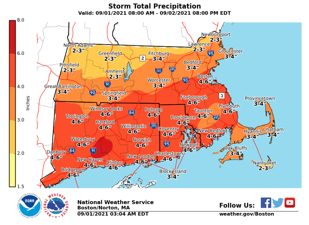
- Near or just south of Pike into eastern MA and parts of SE MA, anomalous 4-5” amounts are possible with isolated pockets of 6-7”. This is very heavy torrential rain and will likely cause flash flood impacts in parts of these areas. Near the south coast of MA, perhaps an area of 3-4” amounts, but trending a bit lower amounts.
- Over the Cape and Islands, amounts of 2.5-3.5” are possible with the lowest over the Islands. If the axis of precipitation trends a bit more northward, amounts over the south coast and the Cape/Islands will be less than this. There are always uncertainties in defining the precipitation axis in a system like this and some changes are likely, but may not be known until radar trends are observed.
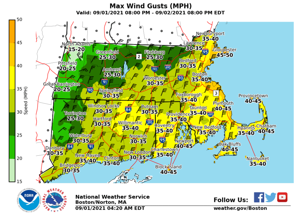
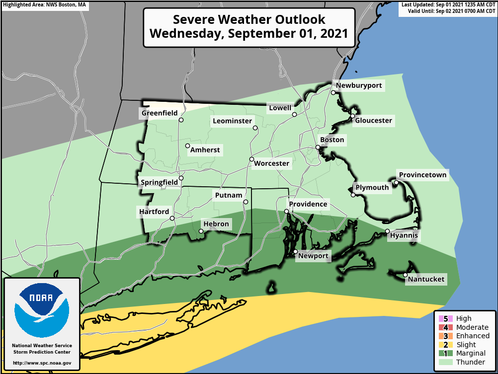
- A low level jet may introduce some stronger winds into the SE MA area as we get into the early hours Thursday morning. Winds of 30-35mph may affect this area Thursday morning with possibly 35-40mph over the Cape Islands. Since the Cape/Islands and south coast/parts of SE MA will be nearer the warm sector, any thunderstorms could become severe with straight line winds or even an isolated tornado spin up (low likelihood).
- Much of this weather will be progressive and should be pushing out of the area by early Thursday afternoon.
Overall Hazards and Impact
- Widespread 2.5-5” of rain with isolated amounts of 6-7” possible.
- Rare high end flood event with significant urban/poor drainage flooding, sharp rises on rivers/waterways, and possible basement flooding.
- Road closures and washouts from excessive rain may impact the Thursday AM commute.
- Possible strong thunderstorms tonight into early Thursday near the south coast; low prob of brief tornado or two.
- Power outages possible given fully leaved trees, saturated grounds, and a period of 30-40 mph wind gusts across eastern MA late tonight and early Thursday.
Post-Event Outlook
A drying trend develops Friday and into the holiday weekend.