
[6:00 PM] July 8, 2021 | Barnstable County Regional Emergency Planning Committee Tropical Storm Elsa Update
Information from Massachusetts Emergency Management Agency
Situation
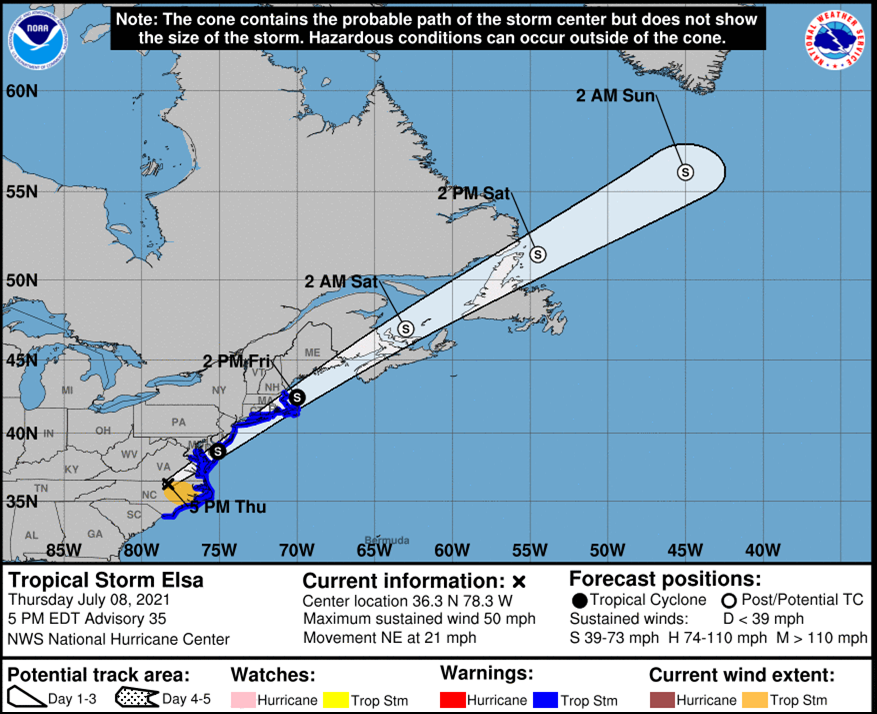
At 5 PM, Tropical Storm Elsa was located 300 miles southwest of Atlantic City, New Jersey with maximum sustained winds of 50 mph and a minimum central pressure of 1006 mb. Elsa is moving toward the northeast near 21 mph. On the forecast track, Elsa will pass near the eastern mid-Atlantic states by tonight and is expected to pass near or over southeast New England on Friday as a tropical storm. No significant change in strength is expected through Friday, and Elsa is forecast to become a Post-tropical Cyclone by Friday night.
Additionally, there will be a risk of some scattered strong to severe storms behind the system, Friday evening.
Elsa is expected to be a fast-moving storm clearing out of MA by early Friday evening.
Impacts/ Potential Impacts
-
- Damaging winds (gusting 40 to 60 mph) and power outages. The greatest area of risk is mainly on Cape Cod and the Islands.
- Heavy rainfall of 2 to 4 inches with isolated totals up to 6 inches. The greatest area of impact will be north/west of Elsa’s track.
- Heavy rainfall could lead to isolated flash flooding and urban flooding.
- Potential for tornadoes Friday morning into the afternoon.
- Potential for dangerous marine conditions along with rough surf and rip currents along south coastal beaches.
No coastal or storm surge flooding is expected.
Please see the weather graphics section of this document for detailed impacts of specific hazards.
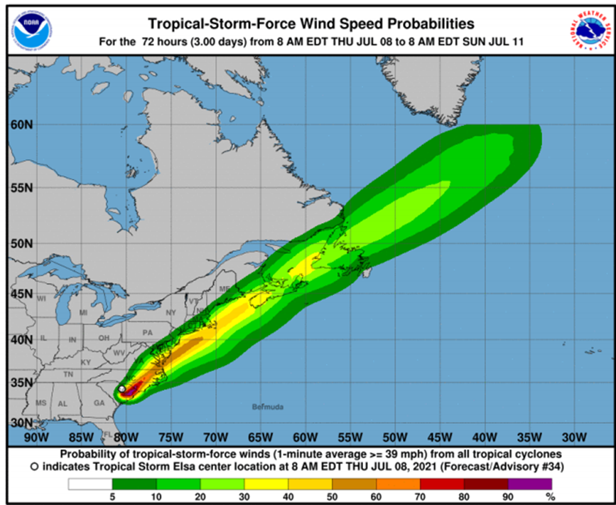
Tropical Storm Winds Probabilities:
- Hyannis 48%
- Nantucket 57%
- Boston 21%
Advisories, Watches, Warnings
- Flash Flood Watch for Central Middlesex County, Eastern Essex, Eastern Norfolk, Eastern Plymouth, Northern Bristol, Northern Worcester, Northwest Middlesex County, Southeast Middlesex, Southern Bristol, Southern Plymouth, Southern Worcester, Suffolk, Western Essex, Western Norfolk, Western Plymouth, Eastern Franklin, Eastern Hampden, Eastern Hampshire, Western Franklin, Western Hampden, Western Hampshire, Northern Berkshire and Southern Berkshire. Issued July 8 at 2:21 PM and Expiring July 9 at 4:00 PM.
- Hurricane Local Statement for all Counties. Issued July 8 at 11:42 AM.
- Tropical Storm Warning for Eastern Essex, Western Norfolk, Southern Middlesex, Suffolk, Eastern Norfolk, Plymouth, Bristol, Barnstable, Dukes, and Nantucket. Issued July 8 at 11:22 AM until further notice.
- A complete list of watches, warnings and advisories in effect for Massachusetts is available at: https://alerts.weather.gov/cap/ma.php?x=1%0A%20%20%20%20%20%20%20%20%20%20%20%20
Tropical Storm Elsa Overview:
- No major changes to the track.
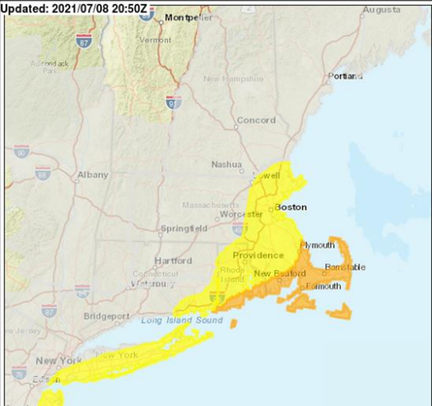
- A Tropical Storm Warning is now in effect as far north as the Merrimack and this includes to the Boston to Providence corridor.
Wind Threat and Potential Impact:
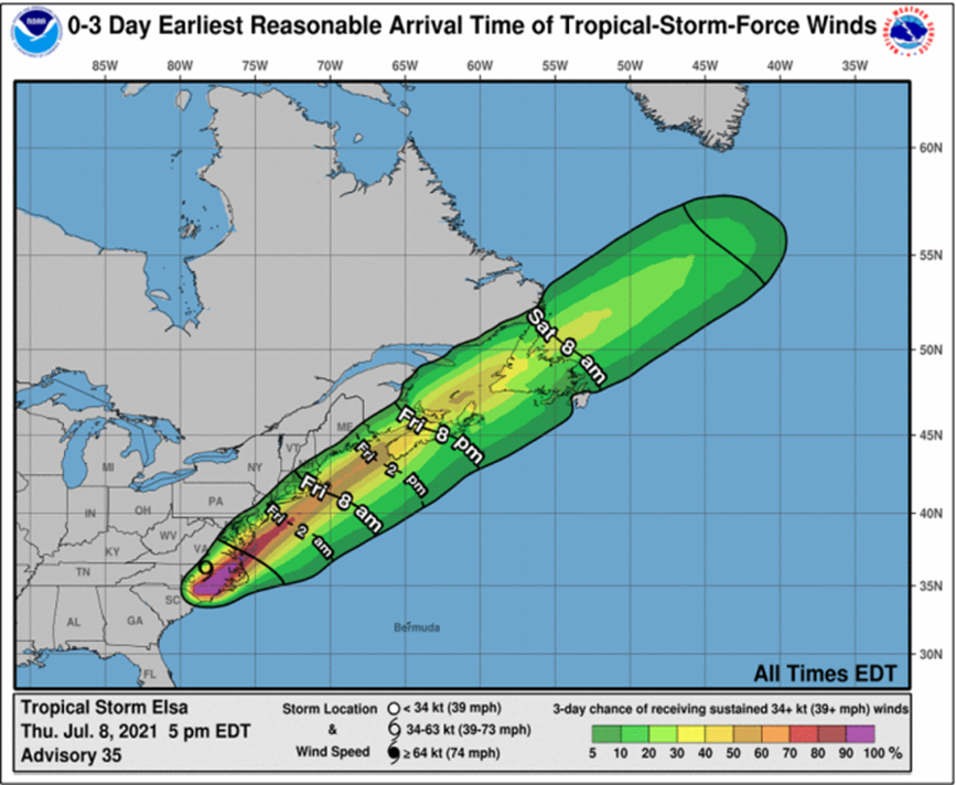
- The winds will start to ramp up after 5 AM Friday with the strongest winds starting around 8AM and peaking around 12:00 PM.
- Potential for 40 to 60 mph gusts on Cape Cod and the Islands.
- The risk for power outages is highest along the south coast, including Cape Cod and the Islands due to damaging winds. There is a lower risk of wind damage and power outages from the Providence to Boston corridor.
Wind Speed and Probabilities:
- Roughly 4 in 10 chance of winds reaching tropical storm force (40 mph sustained) on Nantucket.
- Roughly 2 in 10 chance of tropical storm force winds across southeast Massachusetts.
Earliest Reasonable Time of Arrival:
- The earliest reasonable time of arrival of tropical storm force winds would be Friday morning.
- Period of strongest winds will only be about 8 hours.
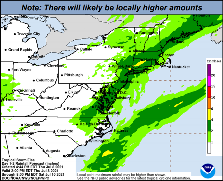
Expected Total Rainfall:
- Elsa could produce 2-4 inches of rain, with isolated amounts up to 6 inches are possible.
- Locally, most rain will occur Friday morning.
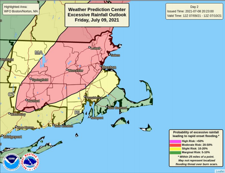
Excessive Rainfall Outlook:
- Areas outlined in red have the greatest potential for flash flooding.
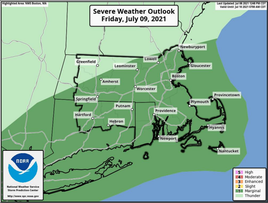
- Tornado Potential:
- The main threat of tornadoes would be Friday morning into Friday afternoon.
- There will be a risk of some scattered strong to severe storms behind the system, Friday evening.
Critical Information |
|
| Public Safety | MA State Police:
|
| Public Works and Engineering | Department of Conservation and Recreation:
Pre-Storm Mobilization Plan The locations for which DCR has responsibility have been prioritized with public safety as the first priority. During the storm, the following locations are DCR priorities:
Mobilization All DCR divisions will mobilize during the regular tour of duty, Friday, July 9, 2021.
|
| Transportation | MA Department of Transportation:
Highway
MBTA
Steamship Authority
|
| Utilities | Department of Public Utilities:
Eversource
National Grid
Unitil
|
| Human Services | Salvation Army:
American Red Cross:
|
| Public Health | Department of Public Health:
|
MEMA Operations
MEMA is coordinating daily conference calls with NWS, Emergency Support Function (ESF) partners, and local and state officials to discuss the forecast for Tropical Storm Elsa, potential impacts, and state/local preparedness actions.
The State Emergency Operations Center (SEOC) is currently operating at Level 1 (Steady State Monitoring). MEMA will continue to monitor the situation and will disseminate additional Situational Awareness Statements, as necessary. The next SAS will be issued tomorrow morning.
[su_box title=”Preparedness and Safety Information ” box_color=”#0099cb”]
Preparedness and safety tips for tropical storms and hurricanes: https://www.mass.gov/info-details/hurricane-safety-tips
Power outage preparedness and safety information: https://www.mass.gov/info-details/power-outage-safety-tips
Preparedness and safety tips for thunderstorms and lightning: https://www.mass.gov/info-details/thunderstorm-and-lightning-safety-tips
Flood safety tips: https://www.mass.gov/info-details/flood-safety-tips[/su_box]
[su_box title=”Stay Informed” box_color=”#0099cb”]
For additional information and updated forecasts, see www.weather.gov/boston (National Weather Service Norton) and www.weather.gov/albany (National Weather Service Albany)
Utilize MEMA’s real-time power outage viewer to stay informed about current power outages in your community and region, and across the state, including information from utility companies about restoration times: http://mema.mapsonline.net/public.html
[/su_box]
[su_box title=”Online Resources” box_color=”#0099cb”]Massachusetts Emergency Management Agency www.mass.gov/mema
MEMA’s Facebook page http://www.facebook.com/MassachusettsEMA
MEMA Twitter @MassEMA
Federal Emergency Management Agency www.fema.gov
National Weather Service Boston/ Norton, MA www.weather.gov/boston
National Weather Service/Albany, NY www.weather.gov/albany
National Weather Service Weather Prediction Center www.wpc.ncep.noaa.gov National Weather Service Storm Prediction Center www.spc.noaa.gov
Northeast River Forecast Center www.weather.gov/nerfc/National Hurricane Center www.nhc.noaa.gov
Mass211 www.mass211.org [/su_box]


