
[3:30 PM] May 26, 2021 | Weather Update
Scattered Strong to Severe Storms Possible Wednesday Afternoon and Evening
[3:30 PM] May 26, 2021 | Update
The most recent guidance suggests that the later timing of the development of storms in western MA should minimalize the impact to our region. The Barnstable County Regional Emergency Planning Committee will continue to monitor the situation. The MACC will remain on standby tonight.
The timing of the upcoming event today is likely to minimize the impacts in central MA and eastern/southeastern MA. Storm time arrival looks to be around 5:00PM to 7:00 PM in western MA where the threat of some severe storms is still a possibility. With storms not arriving until later in central and eastern MA, the loss of maximum daytime heating will diminish the severe threat substantially. There still is a threat for damaging straight line winds in western MA during the indicated timeframe with possibly an isolated tornado risk. Although the risk in eastern and southeastern MA is down considerably, people in central MA should remain alert to the chances that a few strong to severe cells could make it in from western MA before weakening as they move further east encountering a much less favorable environment.
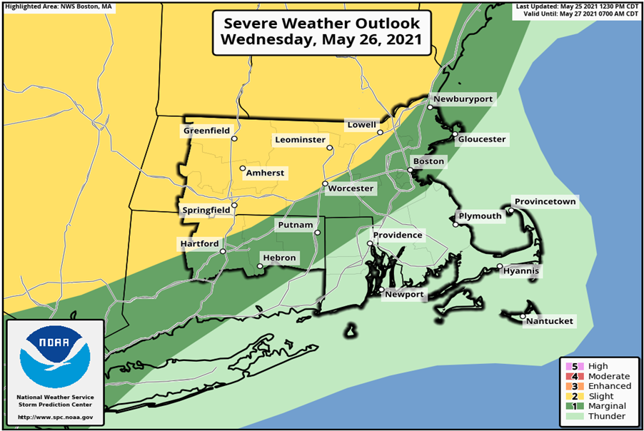
Situation [5:15 PM] May 25, 2021
The National Weather Service (NWS) is forecasting that a passing cold front will generate isolated to scattered, strong to severe, thunderstorms between 2 PM- 8 PM Wednesday. The main threats associated with these storms are strong to damaging winds, hail, frequent lightning, and periods of heavy rainfall with urban and poor drainage flooding. There is also a possibility for an isolated tornado. As depicted in the weather graphic below, the NWS has placed Western and portions of Central MA at slight risk for severe weather and Northeast and Eastern MA at marginal risk for severe weather. The area of greatest risk will be the western portion of the state; west of I-395/1-190. There remains a degree of uncertainty in the forecast for Southeastern MA regarding the extent of strong to severe thunderstorm potential. Dry weather is expected to return overnight and remain in place through Thursday.
Impacts/Potential Impacts
- Damaging wind gusts at or above 58 MPH are possible
- Large hail and an isolated tornado will be possible
- Cloud to ground lightning strikes will accompany thunderstorms
- Brief periods of heavy rainfall with urban and poor drainage flooding
- Scattered tree damage may occur
Weather Forecast Overview
MEMA Operations
The State Emergency Operations Center (SEOC) is operating at Level 1 (Steady State Monitoring). MEMA will continue to monitor the situation and will disseminate additional Situational Awareness Statements, as necessary.
Preparedness and Safety Information
- Safety and preparedness tips for tornadoes:
http://www.mass.gov/index.php/service-details/tornado-safety-tips - Power outage preparedness and safety information:
http://www.mass.gov/index.php/service-details/power-outage-safety-tips - Preparedness and safety tips for thunderstorms and lightning: https://www.mass.gov/index.php/service-details/thunderstorm-and-lightning-safety-tips
Stay Informed
For additional information and updated forecasts, see www.weather.gov/boston (National Weather Service Norton) and www.weather.gov/albany (National Weather Service Albany).
Utilize MEMA’s real-time power outage viewer to stay informed about current power outages in your community and region, and across the state, including information from utility companies about restoration times: http://mema.mapsonline.net/public.html
Online Resources
Barnstable County Regional Emergency Planning Facebook
Barnstable County Regional Emergency Planning Twitter
Massachusetts Emergency Management Agency www.mass.gov/mema
MEMA’s Facebook page http://www.facebook.com/MassachusettsEMA
MEMA Twitter @MassEMA
Federal Emergency Management Agency www.fema.gov
National Weather Service Boston/ Norton, MA www.weather.gov/boston
National Weather Service/Albany, NY www.weather.gov/albany
National Weather Service Weather Prediction Center www.wpc.ncep.noaa.gov/
National Weather Service Storm Prediction Center www.spc.noaa.gov/
Northeast River Forecast Center www.weather.gov/nerfc/
National Hurricane Center www.nhc.noaa.gov
Mass211 www.mass211.org
