
December 24, 2020 | Short Duration Storm on Christmas Eve and Christmas Day
Short Duration Storm on Christmas Eve and Christmas (Potential for Damaging Winds and Minor Flooding)
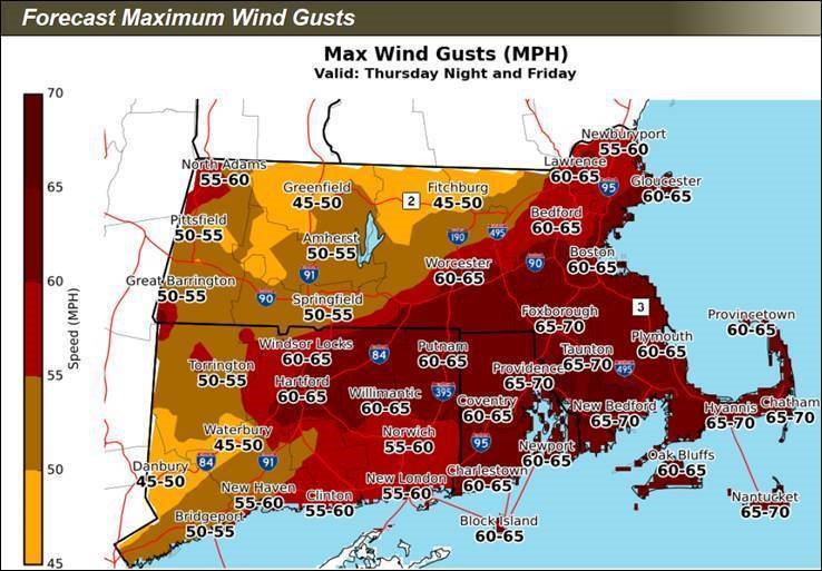
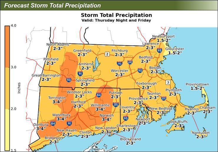
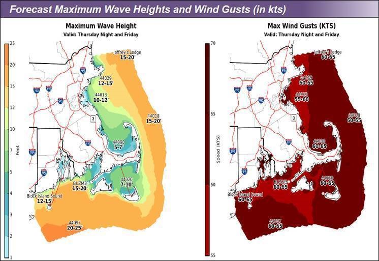
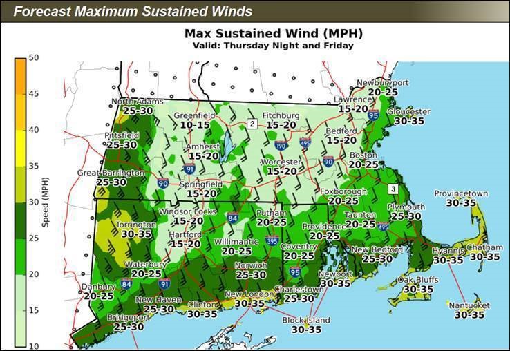
A short duration, strong storm system will bring potentially damaging winds, heavy rain, and localized flooding to the Commonwealth tonight and lasting into Christmas Day (tomorrow). 25-40 mph sustained winds with the potential to increase slightly and damaging Southeastern gusts up to 75 mph are expected throughout Massachusetts, with increasingly powerful gusts over the Cape and Islands. 1.5 to 3 inches of rainfall is possible causing minor river, street/highway, and coastal flooding. Christmas Eve and Day travel impacts can be expected.
Impacts
- Numerous power outages across Massachusetts with a greater risk in Eastern MA.
- Minor river flooding with localized street and highway flooding.
- Poor visibility due to dense fog will cause travel impacts.
- Minor coastal flooding possible on the Southern coast.
Weather Forecast
Rain will gradually develop from west to east across the state later this afternoon but more so this evening and tonight. The rain will gradually increase in intensity during the night and into Christmas Morning. An isolated thunderstorm or two may even occur. Winds will be increasing as well with some gusts in excess of 50-60 mph possible later tonight into Christmas Morning. Windy and rainy conditions will remain through the late morning then begin to diminish from west to east later in Friday afternoon to early evening. The height of winds will be between 5 AM and 10 AM Friday morning with highest gusts in a 2-hour window. While winds will diminish conditions may remain on the breezy side for some overnight.
The rain will likely transition to a period of snow showers by Friday evening/night across parts of western Massachusetts. A light accumulation of snow is possible. One added concern will be the falling temperatures Friday afternoon and Friday evening. Winds should help dry roads before conditions turn icy but any areas shielded from the winds may become icy trouble spots Friday night into Saturday morning. A few snow showers could reach parts of western Massachusetts during the day on Saturday. The higher elevations of the Berkshires will be most at risk for a dusting of snow during the day. Otherwise, drier weather will take hold for the remainder of the holiday weekend.
Watches, Warnings, Advisories (as of 1:09 AM 12/24/20)
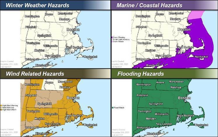
- Flood Watch for Berkshire, Middlesex, Franklin, Hampden, Hampshire, Worcester, Essex, Norfolk, Barnstable, Dukes, Plymouth, Nantucket, Bristol and Suffolk Counties. Issued December 24th at 3:49 AM and Expiring December 25th at 4:00 PM.
- High Wind Warning for Middlesex, Worcester, Essex, Dukes, Norfolk, Plymouth, Nantucket, Bristol and Berkshire Counties. Issued December 24th at 3:30 AM and Expiring December 25th at 4:00 PM.
- Wind Advisory for Franklin, Hampden, Hampshire, Worcester and Middlesex Counties. Issued December 24th at 3:50 AM and Expiring December 25th at 12:00 PM.
- Flood Warning for Berkshire County. Issued December 24th at 1:03 PM and Expiring December 26th at 2:53 AM.
Stay Informed:
Utilize MEMA’s real-time power outage viewer to stay informed about current power outages in your community and region, and across the state, including information from utility companies about restoration times: http://mema.mapsonline.net/public.html
Utilize MEMA’s live weather radar and forecasting tools: http://www.mass.gov/map-resources
Online Resources:
For additional information and resources, visit:
Massachusetts Emergency Management Agency at www.mass.gov/mema
MEMA’s Facebook page: http://www.facebook.com/MassachusettsEMA
MEMA Twitter: @MassEMA
Federal Emergency Management Agency at www.fema.gov
National Weather Service/Norton at www.weather.gov/boston
National Weather Service/Albany, NY at www.weather.gov/albany
National Weather Service Weather Prediction Center: http://www.wpc.ncep.noaa.gov
National Weather Service Storm Prediction Center: http://www.spc.noaa.gov/
Mass211 at www.mass211.org
A complete list of watches, warnings and advisories in effect for Massachusetts is available at: https://alerts.weather.gov/cap/ma.php?x=1%0A%20%20%20%20%20%20%20%20%20%20%20%20
