September 21, 2020 – Gale Warning in Effect
Monday Afternoon
NE winds 20 to 25 kt with gusts up to 35 kt. Seas 9 to 11 ft.
Monday Evening
NE winds 20 to 25 kt with gusts up to 30 kt, increasing to 25 to 30 kt with gusts up to 40 kt after midnight. Seas 9 to 12 ft.
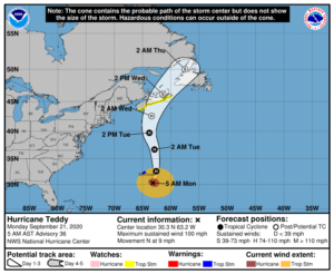
Hurricane Teddy Expected to Bring Significant Marine Event on Tuesday
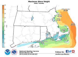
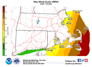
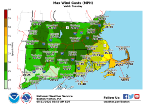
Hurricane Teddy is expected to pass approximately 400 miles east of the Massachusetts coastline on Tuesday. The main impact will be for our marine community. High seas of 15 and 25 feet are likely to develop across the ocean waters east of Cape Cod and Nantucket, as northerly wind gusts to 40 to 50 knots.
Pockets of minor coastal flooding and beach erosion appear likely during the Tuesday afternoon high tide cycle along the eastern Massachusetts coast and particularly across the north facing sides of Cape Cod and Nantucket. While some typically vulnerable shoreline roads may become flooded within a few hours of the high tide, significant coastal flooding is not expected.
High surf and dangerous rip currents are expected on ocean exposed beaches. In addition, given the large surf, viewing the large waves or fishing from jetties and/or piers can be very dangerous and is strongly discouraged.
Northerly wind gusts of 40 to 50 mph are likely across Cape Cod and Nantucket on Tuesday, and seas 8 to 13 feet. No rain is expected from Hurricane Teddy in southern New England.
Barnstable County Regional Emergency Planning Committee will continue to monitor the storm. Should we need to take any additional preparations, we will post additional information.