
Weather Update – May 15, 2020 | Severe Thunderstorms Possible Later Today
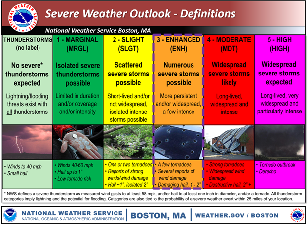
The National Weather Service (NWS) is forecasting that strong to severe thunderstorms will impact the state this afternoon into the evening. Severe thunderstorms are possible later today in Barnstable County. The South Coast, Cape Cod, and the Islands are under a marginal risk.
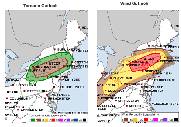
There will be two rounds of severe weather associated with this event. The first round will consist of isolated thunderstorms statewide between 3-7PM. Some of these storms may be severe, with heavy rain, 50-60 MPH wind gusts, and quarter-size hail possible. Beginning at 7PM, an organized line of thunderstorms will then move across the state from west to east. These storms are expected to bring 50-60 MPH wind gusts, large hail, and heavy rain, as well as a low risk (2-5%) of an isolated tornado. Northern and western Massachusetts are most likely to see significant impacts as a result of this event. Most, if not all, thunderstorm activity will dissipate after 10 PM, although scattered showers may persist past midnight, especially in southeastern Massachusetts.
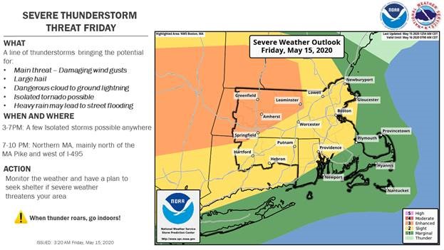
NWS forecast offices will issue updated watches and warnings later today as the severe weather event continues to develop.
Impacts:
- Strong wind gusts may result in tree damage and power outages.
- Heavy rains may cause short-term flooding in urban, low-lying, or poor drainage areas.
- Large hail may cause damage to structures or vehicles.
- There is a low risk of isolated tornado activity.
State Operations
The State Emergency Operations Center (SEOC) at MEMA Headquarters in Framingham is currently operating at Level 3 (Full Activation) to support COVID-19 response efforts. MEMA will continue to monitor this storm event and distribute Situational Awareness Statements, as needed.
Preparedness and Safety Information
- Temporary structures such as tents are vulnerable during severe weather. Communities and agencies are encouraged to closely monitor weather conditions and take appropriate precautions.
- Tornado Safety Tips
- Thunderstorm and Lightning Safety Tips:
Stay Informed
- For additional information and updated forecasts, see www.weather.gov/boston (National Weather Service Norton) and www.weather.gov/albany (National Weather Service Albany)
- Utilize MEMA’s real-time power outage viewer to stay informed about current power outages in your community and region, and across the state, including information from utility companies about restoration times: http://mema.mapsonline.net/public.html
Online Resources
Massachusetts Emergency Management Agency at www.mass.gov/mema
MEMA’s Facebook page: http://www.facebook.com/MassachusettsEMA
MEMA Twitter: @MassEMA
Federal Emergency Management Agency at www.fema.gov
National Weather Service Boston/ Norton, MA at www.weather.gov/boston
National Weather Service/Albany, NY at www.weather.gov/albany
National Weather Service Weather Prediction Center: www.wpc.ncep.noaa.gov/
National Weather Service Storm Prediction Center: www.spc.noaa.gov/
Northeast River Forecast Center: www.weather.gov/nerfc/
Mass211 at www.mass211.org


